Via Czechia Southern Trail Via Czechia Southern Trail

participants
96
The Via Czechia trails represent the longest and most boldly designed long-distance routes in the Czech Republic. They are suitable for hiking, cycling, or winter skiing.

The basic hiking variant of the Southern Trail measures 1052 km and is divided into 44 daily stages with an average length of 20-25 km, always with the option of indoor accommodation. The Southern Trail is also very suitable for cycling; the cycling variant of the Southern Trail measures a total of 1080 km and can be completed in 2-3 weeks. A large part can also be traversed on skis, with a total of 319 km of ski trails, mostly machine-groomed.

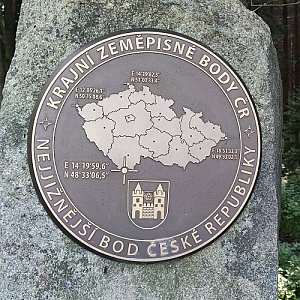
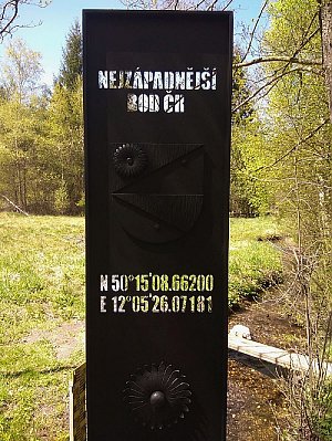
The Southern Trail leads through 15 mountain ranges and geographical units, across 6 protected landscape areas, 2 national parks, and countless nature reserves and natural monuments. If you conquer this trail in its entirety, you will ascend to 20 peaks and stand at the easternmost, southernmost, and westernmost points of the Czech Republic.

Route and information about the Southern Trail


challenge organizer
Malý Polom
1061 m n.m., optional
126 m
Súľov
903 m n.m.
46 m
Lemešná
950 m n.m.
151 m
Veľký Javorník
1075 m n.m.
357 m
Veľký Javorník Z
1071 m n.m.
15 m
Stratenec
1055 m n.m.
32 m
Malý Javorník
1019 m n.m.
49 m
Kohútka
913 m n.m.
35 m
Makyta
923 m n.m.
232 m
Čubův kopec
720 m n.m.
145 m
Končitá
817 m n.m.
77 m
Ploščiny
739 m n.m.
26 m
Stráně
664 m n.m., optional
226 m
Javorník
782 m n.m.
240 m
Mikulčin vrch
799 m n.m.
111 m
Velký Lopeník
911 m n.m.
397 m
Velká Javořina
970 m n.m.
570 m
Nová hora
646 m n.m.
14 m
Hradisko
636 m n.m.
113 m
Bojiště
439 m n.m.
53 m
Kobyla
584 m n.m.
38 m
Šumárník
398 m n.m.
45 m
Travičná
380 m n.m.
56 m
Žerotín
322 m n.m., optional
10 m
Holý vrch
388 m n.m.
2 m
Trojmezí CZ-SK-AT
151 m n.m., optional
0 m
Minaret Lednice
164 m n.m., optional
0 m
Děvín
550 m n.m.
348 m
Lampelberg
289 m n.m., optional
0 m
Bor
Bor
482 m n.m.
0 m
Červené blato
478 m n.m., optional
0 m
Kraví hora
962 m n.m.
144 m
Vysoká
1035 m n.m., optional
210 m
Myslivna
1044 m n.m.
127 m
Kamenec
1073 m n.m.
156 m
Jelení vrch
956 m n.m.
103 m
Vyklestilka
899 m n.m.
18 m
Uhlířský vrch
925 m n.m.
38 m
Velký Plešný
1011 m n.m.
15 m
Vítkův kámen
1036 m n.m.
245 m
Ježová-Iglbach
791 m n.m.
0 m
Rozhledna Moldaublick
1020 m n.m., optional
0 m
Plechý
1378 m n.m.
508 m
Nad Rakouskou loukou
1378 m n.m.
33 m
Trojmezná
1362 m n.m.
38 m
Vysoký hřeben
1341 m n.m., optional
23 m
Nové Údolí
828 m n.m.
0 m
Homole
1056 m n.m., optional
2 m
Bučina
1156 m n.m.
0 m
Modravská hora
1157 m n.m.
64 m
Oblík
1228 m n.m.
77 m
Poledník
1315 m n.m.
185 m
Prášily
878 m n.m.
0 m
Březník
1006 m n.m.
65 m
Jezero Laka
1085 m n.m.
0 m
Polom
1295 m n.m.
102 m
Čertovo jezero
1029 m n.m.
0 m
Špičák
1205 m n.m.
45 m
Ostrý
1292 m n.m.
177 m
U Zadních Chalup Z
752 m n.m.
10 m
Čerchov
1042 m n.m.
527 m
Haltrava
882 m n.m.
50 m
Škarmanka
888 m n.m.
185 m
Starý Herštejn
878 m n.m.
125 m
Velký Zvon
863 m n.m., optional
85 m
Pleš
794 m n.m.
11 m
Rozvadov
563 m n.m.
0 m
Havran
894 m n.m., optional
46 m
Na Skalkách
769 m n.m.
18 m
Tišina
791 m n.m.
70 m
Dyleň
940 m n.m.
336 m
Na Kopci
622 m n.m.
27 m
Zelená hora
637 m n.m.
51 m
Háj
758 m n.m.
108 m
Share