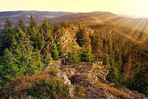
Vysoký hřeben (1341 m a.s.l., Šumava)
Register and log summit


About Vysokém hřebenu
 Česko
 Německo
Prachatice (Jihočeský kraj)
Logged on Vrcholovka 116x in total. Peak information here was completed by Pavel Martínek, Martin Matějka a Vladimír Grančay.
Vysoký hřeben is part of challenges: Šumavské tisícovky, The Highest Peaks of South Bohemia, Thousanders of the Czech Republic, Via Czechia Southern Trail
The ninth highest peak on the Czech side of Šumava is located in the I. zone of the national park and also within a natural monument. It is not accessible, but a hiking trail leads within 80 meters of it.
- Chalet/accommodation
-
There is no chalet on the peak.
- Stroller access
-
Peak is not stroller accessible.
- Views
-
There are views from the peak.
- Cable car
-
There is no cable car to this peak.
- Equipment
-
No special equipment is required for this summit.
- Accessibility
-
The peak is not accessible (I. zone of the national park), but a marked path leads just 80 meters from the summit and only 7 vertical meters lower.
Nearest peaks: Třístoličník / Dreisessel (1311 m, 1 km) Trojmezná (1362 m, 1.2 km) Nashornfelsen (1312 m, 1.3 km) Hochstein (1333 m, 1.4 km) Ptačí skály (1285 m, 1.9 km) Habergrasberg V (1244 m, 2 km) Jakubova chýše (1157 m, 2.2 km) Teufelsschüssel (1108 m, 2.5 km) Fegefeuer-Hexentanz (1085 m, 2.6 km) Jakubova chýše SZ (989 m, 3 km) Jakubova chýše SSZ (995 m, 3.1 km) Habergrasberg S2 (1047 m, 3.3 km) Habergrasberg S1 (1048 m, 3.4 km)
Routes nearby
(elevation gain 10400 m, 1051 km)
 Přechod NP Šumava
(elevation gain 2456 m, 101 km)
Webcams on Vysokém hřebenu
( 1.1 km)
 Schwarzenberg am Bohmerwald: Schwarzenbergbahn Talstation
( 5 km)
 Stozec › South-West: Nové Údolí
( 6.2 km)
 Stozec › South-West
( 6.2 km)
 Haidmuhle: Dreisessel
(827 m a.s.l., 6.2 km)

Sun
| today | tomorrow | day after tomorrow | |
|---|---|---|---|
| Dawn: | 6:14 | 6:15 | 6:17 |
| Sunrise: | 6:46 | 6:48 | 6:49 |
| Sunset: | 16:50 | 16:48 | 16:46 |
| Dusk: | 17:22 | 17:21 | 17:19 |