Plechý S (1337 m a.s.l., Šumava)
Register and log summit

About peak Plechý S
 Česko
Prachatice (Jihočeský kraj)
Logged on Vrcholovka 12x in total. Vrchol Plechý S was added here by Bouřka and info was completed by Martin Matějka a Krtek.
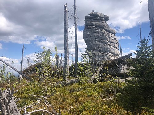
With an elevation of 1337.1 m and a prominence of 5.2 m (both according to height analysis from ČÚZK), this is clearly a new unofficial secondary peak. The summit is in Zone I, but anyone taking the marked trail from the Stifter Memorial can comfortably record it - it's only about 85 m away at the nearest point.
As a colleague writes, just 85 meters, but the terrain is challenging, decaying trunks are covered with new vegetation, so access takes a while. A beautiful place.
- Chalet/accommodation
-
There is no chalet on the peak.
- Stroller access
-
Peak is not stroller accessible.
- Views
-
There are views from the peak.
- Cable car
-
There is no cable car to this peak.
- Equipment
-
No special equipment is required for this summit.
- Accessibility
-
Zone I of the National Park.
Nearest peaks: Plechý S2 (1336 m, 0.2 km) Plechý (1378 m, 0.6 km) Nad Rakouskou loukou (1378 m, 0.9 km) Ptačí skály (1285 m, 1.2 km) Buchenwald (1214 m, 1.9 km) Plöckenstein J (1275 m, 1.9 km) Trojmezná (1362 m, 1.9 km) V Pařezí J2 (1129 m, 2 km) Jakubova chýše (1157 m, 2.2 km) Nad Rakouskou cestou (1054 m, 2.2 km) V Pařezí J (1140 m, 2.2 km) Koňský vrch SZ (1025 m, 2.3 km) Rock Basin (1021 m, 2.3 km) Plöckenstein JV (1228 m, 2.5 km) Rosenauerův les (962 m, 2.6 km) Teufelsschüssel (1108 m, 2.6 km) V Pařezí (1157 m, 2.6 km) Fegefeuer-Hexentanz (1085 m, 2.7 km) At Pařezí V (947 m, 2.8 km) In Pařezí S (1101 m, 3.1 km) V růžku (1095 m, 3.4 km) Jakubova chýše SSZ (995 m, 3.5 km)
Routes nearby
(elevation gain 10400 m, 1051 km)
 Přechod NP Šumava
(elevation gain 2456 m, 101 km)
Webcams
( 3.8 km)
 Schwarzenberg am Bohmerwald: Schwarzenbergbahn Talstation
( 4.4 km)
 Klaffer am Hochficht: Hochficht Böhmerwald - Reischlberg Mittelstation
( 4.8 km)
 Klaffer am Hochficht: Hochficht Böhmerwald - Reischlberg Mittelstation
( 4.8 km)
 Klaffer am Hochficht: Hochficht Böhmerwald - Reischlberg Mittelstation
( 4.8 km)
 Klaffer am Hochficht: Hochficht Böhmerwald - Skiarena Hochficht
( 5.4 km)

Sun
| today | tomorrow | day after tomorrow | |
|---|---|---|---|
| Dawn: | 7:06 | 6:07 | 6:09 |
| Sunrise: | 7:38 | 6:40 | 6:41 |
| Sunset: | 17:58 | 16:57 | 16:55 |
| Dusk: | 18:31 | 17:29 | 17:27 |