Knížecí stolec (1236 m a.s.l., Šumava)
Register and log summit


About Knížecím stolci
 Česko
Český Krumlov (Jihočeský kraj)
Logged on Vrcholovka 81x in total. Peak information here was completed by Martin Matějka, Bouřka a PA!WELL.
Knížecí stolec is part of challenges: Most Isolated, Stamp Peaks, Šumavské tisícovky, Šumavské ultratisícovky, The Highest Peaks of South Bohemia, The Most Prominent Mountains of the Czech Republic, Thousanders of the Czech Republic, Ultrapeaks
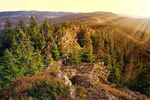
The highest peak of the Šumava subrange Želnavská hornatina and the second most prominent mountain in the Czech part of Šumava. It is located within the military district of Boletice, but from 2012 to 2024, a blue trail led to the summit and it was accessible. There was also a wooden lookout tower that was demolished in January 2024 due to a wood rot infection and an impending access ban. This ban came into effect on May 1, 2024, the blue trail was canceled, and since then the summit has been inaccessible.
- Chalet/accommodation
-
There is no chalet on the peak.
- Stroller access
-
Peak is not stroller accessible.
- Views
-
There are views from the peak.
- Cable car
-
There is no cable car to this peak.
- Equipment
-
No special equipment is required for this summit.
- Accessibility
-
access prohibited in the military area from May 1, 2024
Nearest peaks: Lysá Z (1192 m, 0.5 km) Lysá SZ (1140 m, 0.6 km) Umrlčí hlava (1150 m, 0.9 km) Lysá (1228 m, 1 km) Skalky (1130 m, 1.1 km) Knížecí stolec SZ (1086 m, 1.3 km) Lysá J (1133 m, 1.4 km) Nad Žumberskou cestou (1110 m, 1.5 km) Adolfův kámen (1073 m, 1.6 km) Dlouhý hřbet V (1083 m, 1.6 km) Lysá SZ2 (964 m, 1.7 km) Nad Adolfovskou cestou (1029 m, 1.8 km) Suchá hora (1083 m, 1.8 km) Suchá hora ZSZ (1081 m, 1.8 km) Under Žumberská Path (1033 m, 1.8 km) Nad Novým Špičákem (1084 m, 1.9 km) Uhlíkovský kopec (1011 m, 1.9 km) Nad Adolfovskou cestou SZ (1005 m, 2 km) Suchá hora SZ (1016 m, 2.1 km) Krb JZ (1075 m, 2.2 km) Lysá SZ3 (943 m, 2.2 km) Nad Zadním Borem Z (1044 m, 2.2 km) Uhlíkovský kopec S (986 m, 2.2 km) Jilmový les (970 m, 2.3 km) Nad Novou Tyrolkou (1057 m, 2.3 km) Lysá SZ4 (942 m, 2.4 km) Zlatovec (1042 m, 2.9 km) Špičák S (1076 m, 3 km) Černá stěna (1024 m, 3.1 km) Hvězdáře (1160 m, 3.1 km) Hvězda SZ (1145 m, 3.2 km) Nad Hospodárnicí (1187 m, 3.2 km) Nad Hospodárnicí Z (1182 m, 3.2 km) Nad Hospodárnicí Z2 (1181 m, 3.2 km) Hvězda (1155 m, 3.3 km) Hvězda JV (1144 m, 3.3 km) Hvězda Z (989 m, 3.5 km) Hvězda Z2 (977 m, 3.5 km) Vlčí kámen (1138 m, 3.5 km) Nad Drážkou V (897 m, 3.6 km) Špičák SV (1142 m, 3.9 km)
Routes nearby
(elevation gain 10400 m, 1051 km)
 Přechod NP Šumava
(elevation gain 2456 m, 101 km)
Webcams on Knížecím stolci
(765 m a.s.l., 8.9 km)
 Nová Pec › North-East
(748 m a.s.l., 9.2 km)

Sun
| today | tomorrow | day after tomorrow | |
|---|---|---|---|
| Dawn: | 6:08 | 6:10 | 6:11 |
| Sunrise: | 6:41 | 6:42 | 6:44 |
| Sunset: | 16:54 | 16:52 | 16:50 |
| Dusk: | 17:26 | 17:25 | 17:23 |