Skalky (1130 m a.s.l., Šumava)
Register and log summit


About peak Skalky
 Česko
Český Krumlov (Jihočeský kraj)
Logged on Vrcholovka 18x in total. Peak information here was completed by Pavel Martínek, Martin Matějka a Bouřka.
Skalky is part of challenges: Skalka a Skalky, Šumavské tisícovky, The Highest Peaks of South Bohemia, Thousanders of the Czech Republic
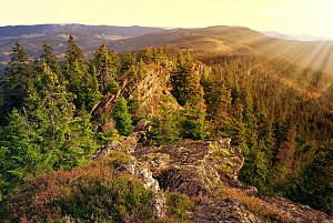
Rocky peak 5 km east of Pěkná. It lies on the northwestern ridge of Knížecí stolec. An asphalt forest road passes through the eastern saddle (1,103 m above sea level). The northwestern ridge is rocky, with the summit formed by a massive (up to 20 m high) rock, surrounded by smaller scree fields. Covered with spruce forest. (tisicovky.cz)
Despite the official inaccessibility, it is very close to marked trails, and the prohibition is rather formal in this case. |Storm|
- Chalet/accommodation
-
There is no chalet on the peak.
- Stroller access
-
Peak is not stroller accessible.
- Views
-
There are no views from the peak.
- Cable car
-
There is no cable car to this peak.
- Equipment
-
No special equipment is required for this summit.
- Accessibility
-
Part of the VVP Boletice.
Nearest peaks: Uhlíkovský kopec (1011 m, 0.8 km) Umrlčí hlava (1150 m, 0.8 km) Dlouhý hřbet V (1083 m, 0.9 km) Knížecí stolec SZ (1086 m, 0.9 km) Uhlíkovský kopec S (986 m, 1 km) Knížecí stolec (1236 m, 1.1 km) Lysá SZ (1140 m, 1.3 km) Nad Adolfovskou cestou SZ (1005 m, 1.3 km) Nad Adolfovskou cestou (1029 m, 1.4 km) Nad Novou Tyrolkou (1057 m, 1.4 km) Suchá hora SZ (1016 m, 1.4 km) Lysá Z (1192 m, 1.5 km) Lysá SZ2 (964 m, 1.7 km) Suchá hora ZSZ (1081 m, 1.7 km) Adolfův kámen (1073 m, 1.8 km) Suchá hora (1083 m, 1.8 km) Lysá SZ3 (943 m, 1.9 km) Černý les SSZ (946 m, 2.1 km) Dlouhý hřbet (1090 m, 2.1 km) Lysá (1228 m, 2.1 km) Černá stěna (1024 m, 2.2 km) Lysá SZ4 (942 m, 2.2 km) Černý les (1007 m, 2.3 km) Black Wall Z (1023 m, 2.4 km) Nad Žumberskou cestou (1110 m, 2.4 km) Under Žumberská Path (1033 m, 2.4 km) Dlouhý hřbet Z (1053 m, 2.5 km) Jilmový les (970 m, 2.7 km) Dlouhý hřbet SZ (1006 m, 3 km) Nad Drážkou V (897 m, 3 km) Bulov SZ1 (963 m, 3.2 km) Bulov SZ2 (956 m, 3.2 km) Bulov SZ3 (953 m, 3.2 km) Bulov SZ4 (944 m, 3.2 km) Nad Drážkou (883 m, 3.2 km) Hvězda SZ (1145 m, 3.3 km) Hvězda Z (989 m, 3.3 km) Hvězda Z2 (977 m, 3.3 km)
Routes nearby
(elevation gain 10400 m, 1051 km)
 Přechod NP Šumava
(elevation gain 2456 m, 101 km)
Webcams
(748 m a.s.l., 8.8 km)
 Horní Planá › South-East: Jihočeský
(765 m a.s.l., 9.4 km)

Sun
| today | tomorrow | day after tomorrow | |
|---|---|---|---|
| Dawn: | 7:05 | 6:07 | 6:08 |
| Sunrise: | 7:38 | 6:39 | 6:41 |
| Sunset: | 17:58 | 16:56 | 16:54 |
| Dusk: | 18:30 | 17:28 | 17:26 |