Černý les (1007 m a.s.l., Šumava)
Register and log summit


About peak Černý les
 Česko
Český Krumlov (Jihočeský kraj)
Logged on Vrcholovka 7x in total. Peak information here was completed by Pája, Martin Matějka a Bouřka.
Černý les is part of challenges: Šumavské tisícovky, Šumavské ultratisícovky, The Highest Peaks of South Bohemia, Thousanders of the Czech Republic, Ultrapeaks
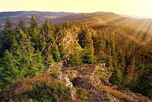
A prominent peak 2 km northeast of Slunečná. The summit has the shape of a regular triangular pyramid, with steep slopes and cliffs. Numerous rocks, scree, and debris flows, with a frost shelter at the top. (...) The vegetation consists of a valuable mixed fir-beech forest, often on a scree substrate. There is a geodetic point at the summit. (tisicovky.cz)
The summit is not officially accessible, but due to its marginal location within the VVP Boletice and the proximity of paths where movement is allowed on weekends and holidays, reaching it is almost possible without problems if one turns a blind eye. When climbing, one must account for the absence of paths; the terrain is rocky in places and covered with lush vegetation, yet for this reason, it is a beautiful peak worth visiting. |Storm|
- Chalet/accommodation
-
There is no chalet on the peak.
- Stroller access
-
Peak is not stroller accessible.
- Views
-
There are views from the peak.
- Cable car
-
There is no cable car to this peak.
- Equipment
-
No special equipment is required for this summit.
- Accessibility
-
The summit is located in the Military District of Boletice. The highest accessible point is about 650 meters southwest of the summit, 150 meters lower in elevation.
Nearest peaks: Černý les SSZ (946 m, 0.6 km) Suchá hora SZ (1016 m, 1 km) Nad Adolfovskou cestou SZ (1005 m, 1.1 km) Nad Uhlíkovem J (880 m, 1.2 km) Nad Adolfovskou cestou (1029 m, 1.4 km) Bulov SZ4 (944 m, 1.5 km) Nad Uhlíkovem (965 m, 1.5 km) Nad Uhlíkovem JZ (859 m, 1.5 km) Bulov SZ2 (956 m, 1.6 km) Bulov SZ3 (953 m, 1.6 km) Uhlíkovský kopec (1011 m, 1.6 km) Bulov SZ1 (963 m, 1.7 km) Nad Uhlíkovem S (952 m, 1.7 km) Suchá hora ZSZ (1081 m, 1.7 km) Uhlíkovský kopec S (986 m, 1.8 km) At the Crossroads (811 m, 1.9 km) Hvězda Z2 (977 m, 1.9 km) Nad Uhlíkovem SSV (928 m, 1.9 km) Nad Uhlíkovem Z (906 m, 1.9 km) Suchá hora (1083 m, 1.9 km) Hvězda Z (989 m, 2.1 km) Nad Mýtinou (945 m, 2.2 km) Umrlčí hlava (1150 m, 2.2 km) Skalky (1130 m, 2.3 km) Dlouhý hřbet ZJZ (968 m, 2.5 km) Hvězda SZ (1145 m, 2.5 km) Nad Hájovnou (836 m, 2.5 km) Dlouhý hřbet (1090 m, 2.7 km) Dlouhý hřbet ZJZ2 (961 m, 2.7 km) U lesíka (777 m, 2.7 km) Hvězda (1155 m, 2.8 km) Dlouhý hřbet V (1083 m, 2.9 km) Dlouhý hřbet Z (1053 m, 2.9 km) Hvězda JV (1144 m, 2.9 km) Nad Hájovnou (995 m, 2.9 km) Nad Novou Tyrolkou (1057 m, 2.9 km) Dlouhý hřbet Z3 (951 m, 3 km) Nad soutoky (813 m, 3 km) Dlouhý hřbet Z2 (955 m, 3.1 km) Želnavský vrch (815 m, 3.3 km) Černá stěna (1024 m, 3.4 km)
Routes nearby
(elevation gain 10400 m, 1051 km)
 Přechod NP Šumava
(elevation gain 2456 m, 101 km)

Sun
| today | tomorrow | day after tomorrow | |
|---|---|---|---|
| Dawn: | 7:03 | 7:04 | 7:06 |
| Sunrise: | 7:35 | 7:36 | 7:38 |
| Sunset: | 18:01 | 18:00 | 17:58 |
| Dusk: | 18:34 | 18:32 | 18:30 |