Lysá (1228 m a.s.l., Šumava)
Register and log summit


About Lysé
 Česko
Český Krumlov (Jihočeský kraj)
Logged on Vrcholovka 25x in total. Peak information here was completed by Pavel Martínek, Martin Matějka, Bouřka a Krtek.
Lysá is part of challenges: Šumavské tisícovky, The Highest Peaks of South Bohemia, Thousanders of the Czech Republic
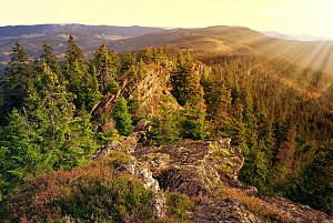
Formerly known as Annina Rock. A prominent peak 7 km east of Pěkná. Flat summit with a distinctive rock on the eastern edge of the Knížecí Stolec massif. Numerous rocks, rock walls, and debris flows. (...) In the lower parts of the southern and eastern slopes, meadows – remnants of the former villages of Nový Špičák, Přední, and Zadní Bor. (...) There is a geodetic point at the summit. (tisicovky.cz)
Once completely forested, the summit was significantly affected by the Kyrill storm, and while in 2020 the area around the summit rock was still covered by a few last spruce trees - the Mohicans, currently (2021) the summit is completely bare and offers excellent views into the distance as well as into the nearby central area of the military training ground, which was previously inhabited. |Storm|
- Chalet/accommodation
-
There is no chalet on the peak.
- Stroller access
-
Peak is not stroller accessible.
- Views
-
There are views from the peak.
- Cable car
-
There is no cable car to this peak.
- Equipment
-
No special equipment is required for this summit.
- Accessibility
-
Military training area Boletice.
Nearest peaks: Lysá Z (1192 m, 0.6 km) Lysá J (1133 m, 0.9 km) Lysá SZ (1140 m, 0.9 km) Knížecí stolec (1236 m, 1 km) Nad Zadním Borem Z (1044 m, 1.1 km) Nad Zadním Borem (1044 m, 1.3 km) Krb JZ (1075 m, 1.6 km) Nad Žumberskou cestou (1110 m, 1.6 km) Nad Novým Špičákem (1084 m, 1.8 km) Knížecí stolec SZ (1086 m, 1.9 km) Umrlčí hlava (1150 m, 1.9 km) Zlatovec J (1009 m, 1.9 km) Jilmový les (970 m, 2 km) Lysá SZ2 (964 m, 2 km) Skalky (1130 m, 2.1 km) Zlatovec (1042 m, 2.1 km) Dlouhý hřbet V (1083 m, 2.3 km) Under Žumberská Path (1033 m, 2.3 km) Adolfův kámen (1073 m, 2.4 km) Lysá SZ3 (943 m, 2.4 km) Lysá SZ4 (942 m, 2.5 km) Suchá hora (1083 m, 2.7 km) Špičák S (1076 m, 2.9 km) Nad Vískou (1053 m, 3.2 km) Nad Vískou SZ (1043 m, 3.2 km) Vlčí kámen (1138 m, 3.2 km) U Dolnošpičácké cesty (949 m, 3.5 km) Hvězdáře (1160 m, 3.6 km) Hvězda (1155 m, 3.9 km)
Routes nearby
(elevation gain 10400 m, 1051 km)
 Přechod NP Šumava
(elevation gain 2456 m, 101 km)
Webcams on Lysé
Cameras provided by windy.com
Sun
| today | tomorrow | day after tomorrow | |
|---|---|---|---|
| Dawn: | 7:02 | 7:04 | 7:05 |
| Sunrise: | 7:35 | 7:36 | 7:38 |
| Sunset: | 18:01 | 17:59 | 17:57 |
| Dusk: | 18:33 | 18:32 | 18:30 |