


Hiking, 15 km
28.12.2025
 Polsko
Logged on Vrcholovka 5x in total. Vrchol Szutrówka/Białe Skały was added here by Bohumír Michal and info was completed by Jiří Králík.
A peak in the Pieniny ridge within Pieniny National Park. The name Białe Skały is used by Józef Nyka in the guide "Pieniny", ISBN 83-915859-4-8. However, on some maps, this peak is marked as Sutrówka.
The mountain is located in the western part of Pieniny, between the peaks of Bajków Groń (721 m) and Ociemny Wierch (740 m). To the north of the summit, a side ridge branches into two parts. The branch leading to Łupiska (659 m) goes north and then descends into the Krośnica valley, while the Wudyky ridge with Zimna Skałka (612 m) descends into the Dunajec valley. The northern slopes are relatively gentle, but to the south, a steep rocky slope drops into the valley of the Pieniński stream. The summit area is covered with forest, but slightly lower, the slopes are dotted with numerous clearings - to the east of the summit lies Kurnikówka, from which the Pieninki clearing extends to the north, and on the mentioned side ridge - among others, Stolarzówka.
On the slope of Białe Skały above the Krośnica valley, there is the Borsucza Jama cave.
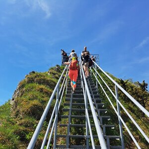
A blue-marked hiking trail, Sokola Perć, passes around the summit.
There is no chalet on the peak.
Peak is not stroller accessible.
There are no views from the peak.
There is no cable car to this peak.
No special equipment is required for this summit.
About 20m from the hiking trail.
Nearest peaks: Mała Szutrówka (736 m, 0.1 km) Bajków Groń (721 m, 0.4 km) Bańków (721 m, 0.4 km) Łupisko (659 m, 0.6 km) Ociemny Wierch (740 m, 0.7 km) Zamkowa Góra (799 m, 0.7 km) Zimna Skała (611 m, 0.9 km) Czerteż (774 m, 1 km) Legarkowe Skałki (829 m, 1 km) Wysoki Dział (731 m, 1 km) Czertezik (772 m, 1.2 km) Pańska Skała (920 m, 1.3 km) Nad Odródki (940 m, 1.4 km) Płaska Skała (950 m, 1.4 km) Trzy Korony (982 m, 1.4 km) Czoło (815 m, 1.5 km) Groń (676 m, 1.5 km) Czoło Z (813 m, 1.7 km) Sokolica (747 m, 1.8 km) Łysina (795 m, 1.9 km) Sylwków Gronik (807 m, 2 km) Długi Gronik (569 m, 2.1 km) Nowa Góra (902 m, 2.1 km) Podskalnia Góra (743 m, 2.1 km) Facimiech (668 m, 2.3 km) Przechodni Wierch (552 m, 2.4 km) Goła Góra (711 m, 2.7 km) Holica (828 m, 2.8 km) Kláštorná hora (657 m, 2.8 km) Klejowa Góra (576 m, 3 km)
| today | tomorrow | day after tomorrow | |
|---|---|---|---|
| Dawn: | 5:56 | 5:57 | 5:59 |
| Sunrise: | 6:29 | 6:31 | 6:33 |
| Sunset: | 16:13 | 16:12 | 16:10 |
| Dusk: | 16:47 | 16:46 | 16:44 |