



Hiking, 15 km
28.12.2025
 Polsko
Logged on Vrcholovka 9x in total. Vrchol Czerteż was added here by Bohumír Michal and info was completed by Jiří Králík.
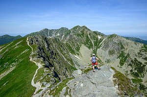
Czerteż (774 m) is the highest peak of the Pieniny ridge, a rocky ridge in the central part of the Pieniny Mountains stretching from Hukowe Skały and Przechodni Wierch to Bajków Groń. This ridge lies between Czertezik (772 m) and Ociemny Wierch (744 m), separated by the Burzana saddle (724 m). The northern slopes of Czerteż descend to the Dunajec River, while the southern slopes drop into the deep and wild valley of the Pieniny Stream. The name comes from a nearby clearing that has since been overgrown with forest and is of Ruthenian origin. In Lemko, the word czerteż, czertiż means logging.
The summit is composed of crinoidal limestone, is forested, and features a steep cliff about 170 m high on the southern side. There is a grassy slope of pale fescue. From the summit, there are views of Sokolica, the Trzy Korony massif, and the Pieniny gorge of the Dunajec River.
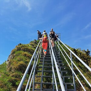
A blue hiking trail, Sokola Perć, leads over the rocky summit and ridge of Czerteż. Dangerous and difficult sections of the Czerteż ridge are secured with metal railings. Hikers who do not enjoy climbing on rocks and steep views can bypass the Czerteż summit via a green trail that runs along the northern slopes of Czerteż on a comfortable forest path from the Burzana saddle to the saddle between Czerteż and Czertezik.
There is no chalet on the peak.
Peak is not stroller accessible.
There are views from the peak.
There is no cable car to this peak.
No special equipment is required for this summit.
Peak is freely accessible.
Nearest peaks: Czertezik (772 m, 0.1 km) Ociemny Wierch (740 m, 0.4 km) Sokolica (747 m, 0.8 km) Zimna Skała (611 m, 0.8 km) Szutrówka/Białe Skały (749 m, 1 km) Zamkowa Góra (799 m, 1 km) Długi Gronik (569 m, 1.1 km) Legarkowe Skałki (829 m, 1.1 km) Mała Szutrówka (736 m, 1.1 km) Bajków Groń (721 m, 1.4 km) Bańków (721 m, 1.4 km) Łupisko (659 m, 1.4 km) Pańska Skała (920 m, 1.4 km) Przechodni Wierch (552 m, 1.4 km) Płaska Skała (950 m, 1.6 km) Łysina (795 m, 1.7 km) Trzy Korony (982 m, 1.7 km) Nad Odródki (940 m, 1.8 km) Holica (828 m, 1.9 km) Facimiech (668 m, 2 km) Wysoki Dział (731 m, 2 km) Bystrzyk (704 m, 2.1 km) Czoło (815 m, 2.2 km) Klejowa Góra (576 m, 2.5 km) Podskalnia Góra (743 m, 2.5 km) Kláštorná hora (657 m, 2.6 km) Bučie (603 m, 2.7 km) Polianka (706 m, 3.4 km)
| today | tomorrow | day after tomorrow | |
|---|---|---|---|
| Dawn: | 6:39 | 6:40 | 5:42 |
| Sunrise: | 7:12 | 7:13 | 6:15 |
| Sunset: | 17:33 | 17:31 | 16:29 |
| Dusk: | 18:05 | 18:04 | 17:02 |