Vilémova výšina (338 m a.s.l., Krušné hory)
Register and log summit

About peak Vilémova výšina
 Česko
Teplice (Ústecký kraj)
Logged on Vrcholovka 1x in total. Vrchol Vilémova výšina was added here by Tor and info was completed by Tor.
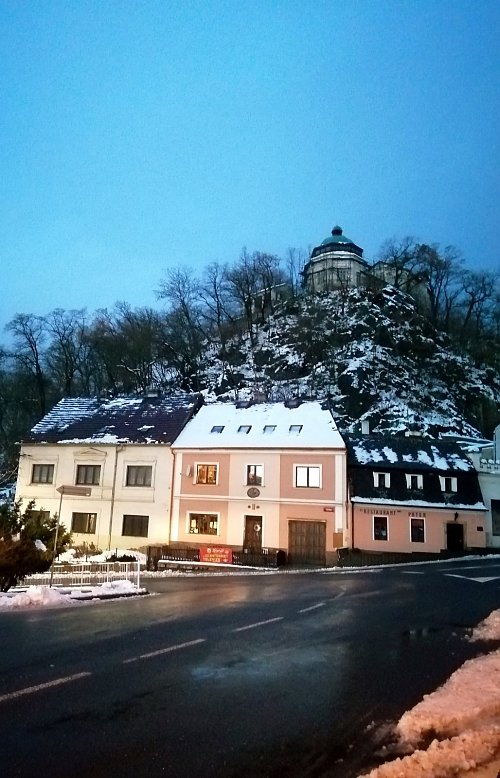
Vilémova výšina rises on the left rocky outcrop above Husitská Street in Krupka. Three hundred years ago, it was called Mlýnský vrch (after the three mills that stood by the stream below it). During the Thirty Years' War, the hill served as a lookout along with the opposite Mrtvý kámen. In 1826, a restaurant with an octagonal observation pavilion was built at the summit, from where spa guests admired the magnificent views of the České středohoří, Rosenberg, and the historic Husitská Street in the 19th and 20th centuries. After a visit from the Prussian King Friedrich Wilhelm (shortly after the restaurant was built), Mlýnský vrch was renamed Vilémova výšina in his honor. The site now serves as a training center and is closed to the public.
- Chalet/accommodation
-
There is a chalet on the peak.
- Stroller access
-
This peak is accessible with a stroller.
- Views
-
There are views from the peak.
- Cable car
-
There is no cable car to this peak.
- Equipment
-
No special equipment is required for this summit.
- Accessibility
-
The area is currently closed to the public.
Nearest peaks: Mrtvý kámen (Totenstein) (334 m, 0.2 km) Rosenberg (368 m, 0.3 km) Lázeňský vrch (422 m, 0.6 km) Ovčí skála (450 m, 0.9 km) Zaječí skála (426 m, 0.9 km) Čihadlo (454 m, 1.2 km) Luisina výšina (394 m, 1.3 km) Mariánská skála (672 m, 1.6 km) Liščí vrch (777 m, 2.3 km) Komáří hůrka (808 m, 2.7 km) Above Sedmihůrky Trail (805 m, 3.5 km)
Webcams
(802 m a.s.l., 2.7 km)
 Krupka › North-East
( 2.7 km)
 Krupka
( 2.7 km)
 Dubi › South
( 4.1 km)
 Dubi › South: Teplice
( 4.1 km)
 Teplice
(248 m a.s.l., 5 km)
 Teplice › South-East
(258 m a.s.l., 5 km)
 Telnice
(754 m a.s.l., 6.8 km)

Sun
| today | tomorrow | day after tomorrow | |
|---|---|---|---|
| Dawn: | 6:24 | 6:26 | 6:28 |
| Sunrise: | 6:59 | 7:01 | 7:02 |
| Sunset: | 16:36 | 16:35 | 16:33 |
| Dusk: | 17:11 | 17:09 | 17:08 |