Hochvernagtwand (3400 m a.s.l., Ötztal Alps)
Register and log summit
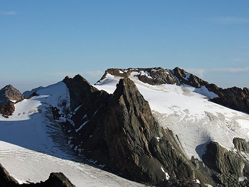

About peak Hochvernagtwand
 Rakousko
Vrchol Hochvernagtwand was added here by Milan "Hojší" Průžek.
https://en.wikipedia.org/wiki/Hochvernagtwand
Hochvernagtwand is a two-summit mountain in the Weisskamm ridge of the Ötztal Alps in the Austrian state of Tyrol. The eastern summit has an elevation of 3,390 m and the western summit 3,400 m, separated by a small saddle. Both summits are rocky, and the glacier reaches almost to the top.
Ascents
The north face is icy and has a steepness of 55°. The winter ascent on skis leads from the Taschachhaus hut above the Pitztal ski area. It is a glacial tour with easy rock climbing at the end.
The southwest ridge is rocky, with a difficulty rating of UIAA grade 1. The summer climbing ascent starts at the Breslauer Hütte hut.
History
The Hochvernagtwand was first ascended on June 25, 1868, by Munich climber Heinrich Waitzenbauer. The first traverse was made during a ridge crossing of the Weisskamm by Heinrich Hess and Ludwig Purtscheller when they crossed from Wildspitze to Hinteren Ölgrubenspitze in the summer of 1887.
[img]https://www.horydoly.cz/files/panorama_sexeger2.jpg[/img]Panorama
- Chalet/accommodation
-
There is no chalet on the peak.
- Stroller access
-
Peak is not stroller accessible.
- Views
-
There are views from the peak.
- Cable car
-
There is no cable car to this peak.
- Equipment
- Accessibility
-
Peak is freely accessible.
Nearest peaks: Hochvernagtspitze (3539 m, 0.8 km) Sexegertenspitze (3424 m, 0.9 km) Nördliche Sexegertenspitze (3348 m, 1.2 km) Fluchtkogel (3494 m, 3.3 km)
Routes nearby
(elevation gain 1900 m, 20 km)
 Nekonečné roviny Oetztálských Alp na sněžnicích či skialpech
(elevation gain 3500 m, 45 km)
 Přechod Mainzer Höhenweg


Sun
| today | tomorrow | day after tomorrow | |
|---|---|---|---|
| Dawn: | 7:13 | 7:15 | 7:16 |
| Sunrise: | 7:44 | 7:46 | 7:47 |
| Sunset: | 18:17 | 18:16 | 18:14 |
| Dusk: | 18:48 | 18:47 | 18:45 |