




Hiking
so, 20.7.2024, 12:30
 Itálie
Logged on Vrcholovka 1x in total. Vrchol Monte Zebrù was added here by Milan "Hojší" Průžek and info was completed by Milan "Hojší" Průžek a Martin Matějka.
Monte Zebrù (Italian pronunciation ˈmonte dzeˈbru) is a mountain in the Ortles-Cevedale group of the Southern Rhaetian Alps, a transitional peak of the coastal Ortles - Monte Zebrù - Gran Zebrù, the least visible but no less important.
It is located on the border between Lombardy and Trentino-Alto Adige. It has steep slopes on all sides except the northern side, where there is a wide glacier tongue. It consists of two peaks: the northwestern peak, which is the summit, and the southeastern peak, which is connected by a thin ridge. Monte Zebrù is connected to Ortles via Giogo Alto and to Gran Zebrù via Passo di Solda. To the northeast, it has a wide and irregular wall of snow and rock, furrowed by ridges descending from the summit ridge, jagged. To the west and southwest, a broad and squat slope of crumbly rocks descends, interrupted by snowy ravines, and finally to the north, the slopes descend with a branch of Vedretta dello Zebrù.
The first confirmed ascent of the mountain was made in 1866 by Julius Payer and Johann Pinggera from the north side, but there remains doubt that in 1854 Stephan Steinberger mistakenly climbed this peak instead of the nearby Gran Zebrù, as he had a topographic map from 1838 that was very inaccurate and indicated a single peak known as "Zebrù" instead of both peaks (D. Chiesa). The Zebrù ridge, starting at Passo di Solda, was crossed in 1880 by B. Minnigerode and Alois Pinggera.
The route from Payer and Pinggera in 1866 led from the southwest in an arc to the northeast across the northwestern slope to the summit. This route is still a common route that can also be undertaken as a ski tour. The base for this route, which can be done as a high-altitude hike, only with appropriate glacier equipment and experience, is the Alpini hut at an altitude of 2878 meters, east above Sant'Antonio in Val Zebrù. According to literature, the walking time is about four hours. Since 1890, very difficult climbing routes with UIAA difficulty II to IV have led, among others, via the western ridge, across the southwest face (Aldo Bonacossa and Carl Prochownik, 1913), and across the northern faces. A new route was opened in 1995 in the western face.
Monte Zebrù is the least visited and wildest mountain of the Ortles-Zebrù range due to the uncomfortable access from the southern side (exhausting and along glaciers with crevasses) and from the northern side (longer and more difficult, along ridges of crumbly rocks and hanging glaciers). It also suffers from the rivalry of its two neighbors.
Normal route: this is the route of the first climbers along the glacier on the north side. It ascends from Vedretta Zebrù, which can be reached from the Quinto Alpini refuge (2877 m), then continues on the left side up to the Giogo Alto pass, where the solid bivouac Città di Cantù (3527 m) stands, and then ascends to the summit over snowy slopes. The difficulty is PD-.
Southeast ridge: this is the ridge connecting both peaks, the main ridge of the mountain, predominantly descending, which forms a beautiful high-altitude traverse with passages in mixed icy and rocky challenging terrain. The difficulty is AD with sections III and III+ in crumbly rock.
Via Tomasson: this is the busiest route on the northeast wall and is a classic of the area. It ascends vertically to the southeast peak through a series of couloirs, which can be accessed via a hanging glacier at the base of the wall. It exceeds 850 m of wall with steps III and ice at 55°, overall D-.
Diemberger Street: this is the most direct alternative to Tomasson Street, sharing access to the wall. It then moves right first in the main couloir, then over snow slabs of the northwestern peak, reaching just below the summit along the ridge, exceeding 850 m of wall with steps III and IV and ice at 55°, grade D.
Other routes on the mountain have been abandoned due to the crumbly nature of the rock and thus high objective danger, also due to the recent reduction of the glacial cover.
The nearest mountain hut is Hochjochbiwak - Bivacco Città di Cantù, located 500 meters northwest of the summit.
Peak is not stroller accessible.
There are views from the peak.
There is no cable car to this peak.
Special equipment is required for this summit.
Peak is freely accessible.
Nearest peaks: Ortler (3905 m, 1.9 km) Thurwieserspitze (3658 m, 2 km) Königspitze/Gran Zebrù (3851 m, 2.1 km)
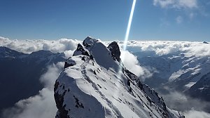 Výstup na horolezecké lákadlo Jižního Tyrolska - Ortler
 Vysokohorská hřebenovka Monte Cevedale - Monte Vioza s možným výstupem na Gran Zebrú
 Sulden - Solda: Madritsch Sessellift
 Sulden - Solda
 Sulden - Solda
 Sulden - Solda
 Stilfs - Stelvio: Sulden - Übungshang Cevedale - Talstation
 Sulden - Solda: Übungshang Cevedale - Talstation
 Albergo della Posta: Solda − Ortles
 Solda: Blick zur Seilbahn
 Valfurva
 Valfurva › North-West
 Solda: Langenstein Kanzel
 Stilfs - Stelvio: Kanzel - Sulden
 Trafoi › South-East: Ortler

| today | tomorrow | day after tomorrow | |
|---|---|---|---|
| Dawn: | 6:18 | 6:19 | 6:21 |
| Sunrise: | 6:49 | 6:50 | 6:52 |
| Sunset: | 17:14 | 17:12 | 17:11 |
| Dusk: | 17:45 | 17:43 | 17:42 |