Daberspitze (3402 m a.s.l., Venediger)
Register and log summit


About peak Daberspitze
 Rakousko
Vrchol Daberspitze was added here by Milan "Hojší" Průžek.
https://cs.wikipedia.org/wiki/Daberspitze
Daberspitze, formerly also known as Hohe Säule (Saile), is a 3402 m high mountain located in the southwestern part of the Venediger mountain group. It is situated in the eastern part of the Austrian federal state of Tyrol, district of Lienz, at the western end of the Umbaltal valley. The northern peak has an elevation of 3330 m, while the southern peak is 3402 m high. The summit has the shape of a steep rocky pyramid and is composed of slate rock that is flaky and crumbling. The southern peak sends out prominent ridges to the north, south, and west, while the northern peak extends to the east. Some climbing routes lead over the ridges. Daberspitze was first ascended on September 17, 1873, by Georg Hofmann from the Munich section of the DAV with mountain guides Josef Berger and Johann Grille, known as Kederbacher.
Location and Surroundings
Daberspitze lies at the southwestern end of the Venediger mountain group and is partially surrounded by glaciers. To the northwest lies the Schwarzachkees glacier, to the northeast, separated by the northern ridge of Daberspitze, is the Welitzkees glacier, and to the southeast is the small Daberkees glacier. The neighboring mountains in the northern ridge, separated by Welitzscharte at an elevation of 3181 m, are Rötspitze (3496 m), to the east Tredeberspitze (3134 m), and the southern ridge features Nördlicher Rotenmannkopf (3127 m). To the east, the area slopes down into the Umbaltal valley, and to the west into the Schwarzachtal valley. The nearest Austrian village is Ströden in the Virgental valley, located about eight and a half kilometers in a straight line to the east.
Base Points and Ascent
The route taken by the first climbers in 1873 led from the newly built Clarahütte hut along the entire southern ridge and took about six hours of walking. The current normal route, the easiest ascent, used since 1904, follows the southern ridge only in the upper part. The Clarahütte hut at an elevation of 2038 m in the upper Umbaltal also serves as a base. The trail leads as a high mountain hike first westward to the small Tredeberkees glacier to the southern Tredeberscharte (3080 m). Across the Daberkees glacier, one reaches the eastern wall of the summit and the upper part of the southern ridge. The difficulty level is UIAA I with a height difference of 1363 m and a walking time of five hours. Alpine climbing has been practiced on Daberspitze since 1904. A route with a difficulty of UIAA III leads through the gully of the eastern wall, which is prone to rockfalls, and also along the northern ridge. In 1925 and 1938, two routes of UIAA IV difficulty were opened through the northwestern wall.
- Chalet/accommodation
-
There is no chalet on the peak.
- Stroller access
-
Peak is not stroller accessible.
- Views
-
There are views from the peak.
- Cable car
-
There is no cable car to this peak.
- Equipment
- Accessibility
-
Peak is freely accessible.
Nearest peaks: Rötspitze (3495 m, 1.2 km) Untere Rötspitze (3289 m, 1.8 km)
Routes nearby
(elevation gain 1100 m, 15 km)
 Typický zástupce ledovcové túry - Dreiherrenspitze
(elevation gain 2200 m, 25 km)
Výšlap na Zillerplatenspitze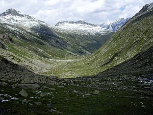
Mountain chalets
Webcams
Cameras provided by windy.com
Sun
| today | tomorrow | day after tomorrow | |
|---|---|---|---|
| Dawn: | 7:09 | 7:11 | 6:12 |
| Sunrise: | 7:40 | 7:42 | 6:43 |
| Sunset: | 18:10 | 18:08 | 17:06 |
| Dusk: | 18:41 | 18:39 | 17:38 |