Hiking, 13 km
11.8.2026
 Česko
Hlavní město Praha (Hlavní město Praha)
Logged on Vrcholovka 275x in total. Vrchol Šance was added here by Pája and info was completed by Martin Matějka, Trailrunner a Zdeněk Munzar.
Šance is part of challenge: Highest Peaks of Prague
At the summit, there is a national cultural monument - a late La Tène fortification from the mid-1st century BC, which is likely a refuge of the Celtic oppidum Závist, whose main part is located on the southern Hradiště at 389 m above sea level. The fortification at Šance has been modified several times during the Middle Ages and early modern period, yet it remains a unique fortification complex of pan-European significance. The northern rampart is, however, being severely damaged by bikers who have made a trail out of it.
The hill also gives its name to the Šance nature reserve, which extends over it and partially onto the adjacent Čihadlo. The nature reserve is part of the European significant site Břežanské údolí, which, alongside the Šance nature reserve, also includes the opposite hill Hradiště. The Šance nature reserve is part of the Modřanská rokle - Cholupice natural park, which is the largest and most significant protected area in the region.
The summit is located on the ramparts built by the Celts, so the height of the hill itself can only be estimated. According to the analysis of the elevation profile, the highest part of the area within the ramparts is at an altitude of about 380 m above sea level (+/- 0.5 m).
There is no chalet on the peak.
This peak is accessible with a stroller.
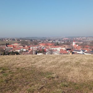
From the summit itself, there is no view, but the southern edge of the hill, open to the Břežanské údolí, offers several viewpoints - Na Špičce (along the side of Šance to Hradiště), Nickerle's (correctly Nickerl's) viewpoint with a memorial plaque of both entomologists Nickerl (into Břežanské údolí), and viewpoints from the Sluneční stráně (over Břežanské údolí and the Vltava River to Zbraslav).
There is no cable car to this peak.
No special equipment is required for this summit.
Peak is freely accessible.
Nearest peaks: Čihadlo (388 m, 0.7 km) Hradiště (389 m, 1.2 km) Spálenka (346 m, 1.2 km) V Hájích (310 m, 2 km) Hradišťátko (348 m, 2.2 km) Cholupický vrch (306 m, 3.3 km) Homole S (333 m, 3.4 km)
| today | tomorrow | day after tomorrow | |
|---|---|---|---|
| Dawn: | 7:05 | 6:07 | 6:08 |
| Sunrise: | 7:38 | 6:40 | 6:42 |
| Sunset: | 17:54 | 16:52 | 16:50 |
| Dusk: | 18:27 | 17:25 | 17:23 |