Bocche
| Highest peak | Cima Bocche / Simon de Boce (2745 m a.s.l.) |
|---|---|
| Most prominent peak | Cima Bocche / Simon de Boce (2745 m a.s.l., prominence 712 m) |
| Parent unit | Western Dolomites |
| Main peaks | Total 10 |
| Most popular peaks | Cima Lasté (2500 m a.s.l.), Monte Pradazzo (2279 m a.s.l.), Col Margherita (2550 m a.s.l.), Spiz del Gronton (2622 m a.s.l.), Sas de Mezdi (2301 m a.s.l.) |

| Name | Elevation | ||||
|---|---|---|---|---|---|
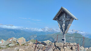
|
Cima Bocche / Simon de Boce | 2745 m a.s.l. | Bocche | 712 m | hlavní vrchol |

|
Spiz del Gronton | 2622 m a.s.l. | Bocche | 235 m | hlavní vrchol |

|
Col Margherita | 2550 m a.s.l. | Bocche | 41 m | hlavní vrchol |

|
Cima Lasté | 2500 m a.s.l. | Bocche | 155 m | hlavní vrchol |

|
Viezzena | 2491 m a.s.l. | Bocche | 438 m | hlavní vrchol |

|
Cima de le Mandre | 2367 m a.s.l. | Bocche | 22 m | hlavní vrchol |
|
|
Sas de Mezdi | 2301 m a.s.l. | Bocche | 157 m | hlavní vrchol |

|
Col de Poza | 2280 m a.s.l. | Bocche | 65 m | hlavní vrchol |

|
Monte Pradazzo | 2279 m a.s.l. | Bocche | 60 m | hlavní vrchol |

|
Le Cune | 2270 m a.s.l. | Bocche | 35 m | hlavní vrchol |