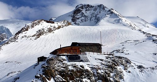
Rifugio città di Mantova (3498 m n.m., Walliské Alpy)


Hodnocení: 4,0 / 5
Kontakty
| Telefon | +39016378150 |
|---|---|
| [email protected] | |
| Web | www.rifugiomantova.it |
| Rifugio città di Mantova |
About chalet Rifugio città di Mantova
 Itálie
The Mantova Hut, officially opened in 1984, is owned by the Alpine Guides of Gressoney and is located at an altitude of 3,498 meters above sea level on the Garstelet Glacier, making it an ideal starting point for all climbing trips to Monte Rosa. After 24 years of operation, the hut underwent extensive renovations that began in 2007 to enhance customer comfort.
Thanks to this extension, there are now toilets that were previously located outside the hut in the basement area. A very important service, often underestimated by shelters, is the ability to offer customers shower facilities, which will finally be possible thanks to three shower stalls designated for guests.
The basement also features a large changing room where climbers can change and store their climbing gear.
On the ground floor, a large dining room with a magnificent view of Monte Rosa and the entire Alpine range up to Mont Blanc and Gran Paradiso, with a capacity of about 100 seats, meets the shelter's capacity requirements in terms of seating - beds, which will remain almost unchanged with 100 beds. The shelter has rooms for three, four, seven people, and a large room for thirty.
The new management is entrusted to three alpine guides from Gressoney, who are fully available to help you organize your trip in the best possible way.
How to get there
From the arrival of the new cable car "Passo dei Salati Indren" in about 40 minutes, first across the Indren Glacier and then along the equipped path up to the hut.
Nearest peaks: Rifugio Mantova (3510 m, 0.1 km) Punta Giovanni Gnifetti (3646 m, 0.6 km) Punta Indren (3275 m, 0.8 km) Punta Luce (3348 m, 0.8 km) Punta Indren SV (3306 m, 0.9 km) Alta Luce (3184 m, 1.7 km) Colletto dell'Acqua (3201 m, 1.7 km) Pyramid Vincent (4215 m, 1.8 km) Punta Giordani / Giordanispétz (4046 m, 1.9 km) Stolemberg (3202 m, 2 km) Punta Salza (2909 m, 2.1 km) Balmenhorn (4167 m, 2.2 km) Schwarzhorn / Corno Nero (4321 m, 2.4 km) Naso del Lyskamm (4272 m, 2.6 km) Ludwigshöhe (4341 m, 2.7 km) Passo dei Salati (2984 m, 2.7 km) Cima di Scoperta (4335 m, 2.9 km) Colle del Lys (4254 m, 2.9 km) Corno del Camoscio (3024 m, 2.9 km) Entdeckungsfelsen (4178 m, 2.9 km) Liskamm East / Lyskamm Orientale (4527 m, 3.2 km) Parrotspitze / Punta Parrot (4443 m, 3.3 km) Punta Telcio (2833 m, 3.3 km)
- Card payment
- Accommodation
-
Accommodation is available in the chalet.
- Dogs
-
Dogs are not allowed in the chalet.
- Refreshments
-
Refreshments available here.
- Wifi
-
Wifi is available in the chalet.
- Mobile signal
-
Mobile signal is available in the chalet or nearby area.