Montaña Vizcaíno (499 m a.s.l., Fuerteventura)
Register and log summit


About peak Montaña Vizcaíno
Španělsko
Vrchol Montaña Vizcaíno was added here by Jiří Králík and info was completed by Martin Matějka.
The mountain is part of the Coastal Ridge Trail. There is no marked path here. The summit has three ridges, all presenting a certain obstacle with a difficulty of UIAA II. To the west of the summit, there is a yellow-marked trail through the Degollada de Cofete pass, which can be used as an approach. The summit is one of the more challenging sections of the ridge.
- Chalet/accommodation
-
There is no chalet on the peak.
- Stroller access
-
Peak is not stroller accessible.
- Views
-
There are views from the peak.
- Cable car
-
There is no cable car to this peak.
- Equipment
-
No special equipment is required for this summit.
- Accessibility
-
Peak is freely accessible.
Nearest peaks: Torreta de Asno (585 m, 1.1 km) Morro del Cavadero (753 m, 1.5 km) Fraile (688 m, 1.6 km) La Montañeta (78 m, 1.8 km) Cuchillo del Ciervo (474 m, 1.9 km) Morro de la Habana (528 m, 2 km) Pico de la Palma (744 m, 2 km) Morro de Munguía (303 m, 2.1 km) Pico de la Zarza (814 m, 2.5 km) Piedras de Tehera (448 m, 2.6 km) Pico de la Camella (314 m, 2.8 km) Pico Alto (399 m, 2.9 km) Torreta de Esquinzo (789 m, 2.9 km) Pico de Tehera (447 m, 3.1 km) Pico de Mocán (801 m, 3.3 km) Cerro Bermejo (398 m, 3.8 km) Morro Jable (230 m, 4.3 km)
Routes nearby
Routes provided by SvetOutdooru.cz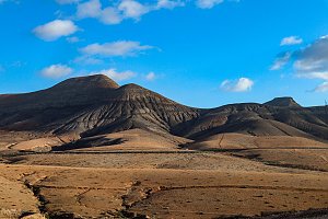
Sun
| today | tomorrow | day after tomorrow | |
|---|---|---|---|
| Dawn: | 6:49 | 6:50 | 6:50 |
| Sunrise: | 7:13 | 7:14 | 7:15 |
| Sunset: | 18:08 | 18:07 | 18:07 |
| Dusk: | 18:32 | 18:32 | 18:31 |