


Hiking, 13 km
29.10.2024
 Španělsko
Logged on Vrcholovka 7x in total. Vrchol Pico de la Zarza was added here by Buchtikovi and info was completed by Jiří Králík a Martin Matějka.
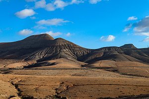
The highest peak of the Canary Island of Fuerteventura. Sometimes referred to as Jandía. The mountain is part of the Coastal Ridge Trail. There is a yellow-marked path that leads almost to the summit along a gravel road and then on a well-trodden trail. The summit is surrounded by several lines of fencing, allegedly to keep goats from nibbling on the yellow-flowering plants at the top so we can admire the flowers. Unfortunately, this has done more harm than good, as the fences do not work as intended, are extremely ugly and damaged, and are a shocking intrusion into the landscape at the summit. Despite three layers of fencing, goats still roam inside. Those who hike the ridge must navigate around the fences. For many tourists following the yellow trail, the summit will undoubtedly be an experience, but for mountaineers on the ridge, it is a disappointment, and they will surely agree that the surrounding peaks are much more beautiful both in appearance and in the views they offer.
There is no chalet on the peak.
Peak is not stroller accessible.
There are views from the peak.
There is no cable car to this peak.
No special equipment is required for this summit.
Peak is freely accessible.
Nearest peaks: Torreta de Esquinzo (789 m, 0.4 km) Pico de la Palma (744 m, 0.6 km) Pico de Mocán (801 m, 0.7 km) Morro del Cavadero (753 m, 1.1 km) Pico de la Matanza (645 m, 1.6 km) Castillejo Alto (569 m, 2 km) Morro del Puerco (587 m, 2.2 km) Montaña Vizcaíno (499 m, 2.5 km) Piedras de Tehera (448 m, 2.7 km) Morro del Joaro (632 m, 2.8 km) Cuchillo del Ciervo (474 m, 3.1 km) Los Castillejitos (420 m, 3.1 km) Pico de Tehera (447 m, 3.1 km) Pico del Viento (421 m, 3.7 km)
| today | tomorrow | day after tomorrow | |
|---|---|---|---|
| Dawn: | 6:43 | 6:44 | 6:44 |
| Sunrise: | 7:07 | 7:08 | 7:08 |
| Sunset: | 18:14 | 18:13 | 18:13 |
| Dusk: | 18:38 | 18:38 | 18:37 |











