Narodnaja (1895 m a.s.l., Přípolar Ural)
Register and log summit
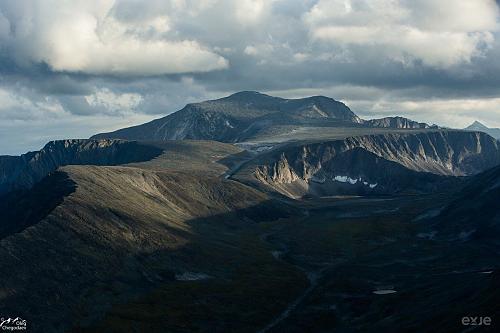

About peak Narodnaja
 Rusko
Peak information here was completed by Martin Matějka.
Narodnaja is part of challenges: Crown of Europe, Highest Geographical Points of Europe, Highest Mountains of European Countries, Ultraprominent Europe
The highest mountain of the Ural and the European part of Russia. The normal ascent route starts from the north, from the Baza Zhelannaya camp (База Желанная, English transcription Baza Zhelannaya) and is very long (about 25 km one way) and navigation-intensive (there are no paths, only tundra and mountains). It leads through the territory of the Jugyd Va National Park, across endless stone seas at higher altitudes and crosses smaller glaciers (depending on snow and ice cover, crampons may be necessary). Access to the camp is also logistically challenging - ideally by train to the city of Inta and then with arranged local transport and a sturdy truck over a roughly 200 km long road, which also crosses relatively wide rivers.
More info in an interesting report on SvetOutdooru.cz.
- Chalet/accommodation
-
There is no chalet on the peak.
- Stroller access
-
Peak is not stroller accessible.
- Views
-
There are views from the peak.
- Cable car
-
There is no cable car to this peak.
- Equipment
-
at higher snow/ice cover, crampons; at lower altitudes, a mosquito net against swarms of mosquitoes
- Accessibility
-
Peak is freely accessible.
Sun
| today | tomorrow | day after tomorrow | |
|---|---|---|---|
| Dawn: | 7:25 | 7:28 | 7:31 |
| Sunrise: | 8:17 | 8:21 | 8:24 |
| Sunset: | 17:09 | 17:06 | 17:02 |
| Dusk: | 18:01 | 17:58 | 17:55 |