Smrčina S (1304 m a.s.l., Šumava)
Register and log summit


About Smrčině
 Česko
Český Krumlov (Jihočeský kraj)
Logged on Vrcholovka 11x in total. Peak information here was completed by Bouřka a Martin Matějka.
Smrčina S is part of challenges: Šumavské tisícovky, The Highest Peaks of South Bohemia, Thousanders of the Czech Republic
A relatively difficult-to-access peak in the I. zone of the National Park. Marked by a geodetic pole.
- Chalet/accommodation
-
There is no chalet on the peak.
- Stroller access
-
Peak is not stroller accessible.
- Views
-
There are no views from the peak.
- Cable car
-
There is no cable car to this peak.
- Equipment
-
No special equipment is required for this summit.
- Accessibility
-
I. zone of the Šumava National Park.
Nearest peaks: Schönbergfelsen (1305 m, 0.7 km) Smrčina/Hochficht (1338 m, 1 km) Stinglfelsen (1260 m, 1.5 km) Hraničník (1282 m, 1.6 km) Fleischhackerberg (1222 m, 1.8 km) Kopka (1119 m, 1.8 km) Kaltebenfelsen (1146 m, 2.1 km) Studničná (1160 m, 2.3 km) U Hájovny (793 m, 2.6 km) Pod Klápou (799 m, 3.2 km) Obere Grüneisfelsen (1047 m, 3.3 km) Fleischhackerberg JV2 (1035 m, 3.4 km) Fleischhackerberg JV (1040 m, 3.5 km)
Routes nearby
(elevation gain 10400 m, 1051 km)
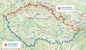 Přechod NP Šumava
(elevation gain 2456 m, 101 km)
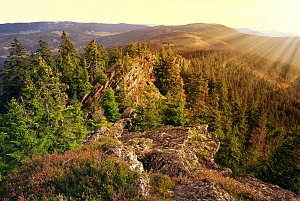
Webcams on Smrčině
( 1 km)
 Klaffer am Hochficht: Hochficht Böhmerwald - Skiarena Hochficht
( 2.1 km)
 Klaffer am Hochficht: Hochficht Böhmerwald - Reischlberg Mittelstation
( 2.1 km)
 Klaffer am Hochficht: Hochficht Böhmerwald - Reischlberg Mittelstation
( 2.1 km)
 Klaffer am Hochficht: Hochficht Böhmerwald - Reischlberg Mittelstation
( 2.1 km)
 Nová Pec › North-East
(748 m a.s.l., 4.4 km)
 Ulrichsberg: Schöneben - Nordisches Zentrum Böhmerwald
( 4.8 km)
 Ulrichsberg: Schöneben - Nordisches Zentrum Böhmerwald
( 4.8 km)
 Ulrichsberg: Schöneben - Nordisches Zentrum Böhmerwald
( 4.8 km)
 Ulrichsberg: Schöneben - Nordisches Zentrum Böhmerwald
( 4.8 km)

Sun
| today | tomorrow | day after tomorrow | |
|---|---|---|---|
| Dawn: | 6:09 | 6:10 | 6:12 |
| Sunrise: | 6:41 | 6:43 | 6:44 |
| Sunset: | 16:55 | 16:53 | 16:51 |
| Dusk: | 17:27 | 17:25 | 17:24 |