


Hiking
st, 29.8.2018

 Ukrajina
Logged on Vrcholovka 2x in total. Vrchol Menčul was added here by Milan "Hojší" Průžek and info was completed by Martin Matějka.
Menčul (Ukrainian Менчул, 1998 m a.s.l.) is a mountain in the Chornohora range in the southwestern part of Ukraine, on the border between the Zakarpattia and Ivano-Frankivsk regions. It is located in the main ridge between the peaks of Brebeneskul (2035 m) to the northwest and Dzembroňa (1877 m) to the southeast. To the southwest, a ridge descends from the mountain through several lower peaks into the valley of the Bílá Tisa River, while in the opposite direction, a ridge leads towards the peak of Stepanec (1649 m). The northern slopes of the mountain drop into the valley of the Kyzja stream, the eastern into the valley of the Dzembroňa stream, the southern into the valley of the Balzatul stream, and the western into the valley of the Brebeneskul stream.
Access:
via the red-marked ridge trail from Hoverla or from Pop Ivan
There is no chalet on the peak.
Peak is not stroller accessible.
There are views from the peak.
There is no cable car to this peak.
No special equipment is required for this summit.
Peak is freely accessible.
Nearest peaks: Brebeneskul (2038 m, 1.4 km) Hora Dzembronya (1877 m, 1.8 km)
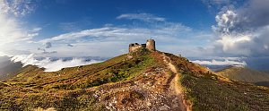 Výstup na nejvyšší ukrajinský vrchol - Hoverlu
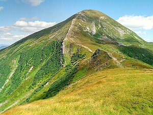 Přechod ukrajinských polonin Maramureš a Černohorská polonina
| today | tomorrow | day after tomorrow | |
|---|---|---|---|
| Dawn: | 7:21 | 7:22 | 6:24 |
| Sunrise: | 7:52 | 7:54 | 6:55 |
| Sunset: | 18:18 | 18:17 | 17:15 |
| Dusk: | 18:50 | 18:48 | 17:47 |

