Hiking, 15 km
3.10.2026
 Česko
Cheb (Karlovarský kraj)
Logged on Vrcholovka 37x in total. Vrchol Podhorní vrch was added here by Milan "Hojší" Průžek and info was completed by Martin Matějka, Petr Wendler, Bouřka a Michal.
Podhorní vrch is part of challenges: Czech Crown, Czech Volcanoes
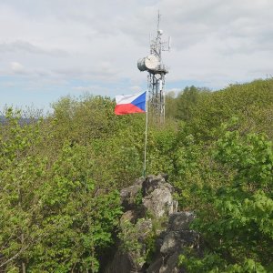
The highest mountain of the Tepelské Highlands and a former volcano, formed by volcanic activity in the Tertiary period about 12 to 15 million years ago. It is one of the youngest remnants of volcanic activity in the Ohře Rift. The summit is forested with deciduous trees, thus lacking a view; for that, one must go to the neighboring Malá Podhora (also 850 m). In the saddle between the two peaks stands a metal radio communication tower. At the southern foot runs the railway line 149 Mariánské Lázně – Karlovy Vary. The area is heavily visited by tourists, especially the viewpoint peak.
Note on height: The height of 847 m indicated on maps is only the height of the geodetic point; the highest spot is on a rock nearby (see photo taken from the mentioned geodetic point) and reaches 850 m (849.7 m on the ČÚZK map and 849.5 m according to elevation analysis). According to the ČÚZK map, the neighboring Malá Podhora (850.1 m) is a few centimeters higher, but the difference is unconvincing and may not be accurate, so for now, Podhorní vrch remains the highest mountain of the Tepelské Highlands.
There is no chalet on the peak.
Peak is not stroller accessible.
There are no views from the peak.
There is no cable car to this peak.
No special equipment is required for this summit.
No path, you need to make your own, through nettles (outside of winter months). Beware of the water reservoir near the summit, which is poorly visible - danger of falling into it.
Nearest peaks: Malá Podhora (850 m, 0.2 km) Milhostovský kopec (750 m, 1.6 km) On the Flat NW (704 m, 1.6 km) Na rovince (731 m, 1.9 km) Na tranďáku (733 m, 2.1 km) Zádubská výšina V (777 m, 2.1 km) Above Jilmový Stream (700 m, 2.4 km) Homolka (783 m, 2.4 km) U sv. Vavřince (735 m, 2.4 km) Služetínský vrch (774 m, 2.7 km) To Číhaná SE (770 m, 2.7 km) Na Kopci (659 m, 2.9 km) K Číhané (773 m, 3 km) Rájovský vrch (789 m, 3.2 km) Jilmový vrch (659 m, 3.4 km)
| today | tomorrow | day after tomorrow | |
|---|---|---|---|
| Dawn: | 6:16 | 6:18 | 6:20 |
| Sunrise: | 6:50 | 6:51 | 6:53 |
| Sunset: | 16:55 | 16:53 | 16:51 |
| Dusk: | 17:28 | 17:26 | 17:25 |