Hiking, 15 km
3.10.2026
 Česko
Cheb (Karlovarský kraj)
Logged on Vrcholovka 18x in total. Vrchol Malá Podhora was added here by Bouřka and info was completed by Bouřka a Michal.
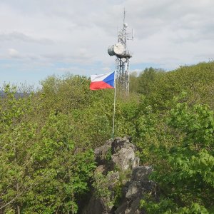
The summit itself is a small rock, accessible via a marked trail. This is where the vast majority of visitors head, often overlooking the northern/main summit of Podhorní vrch. The view includes a sector from the NE to the SW, with sights such as Brdy, Šumava (on clear days, the 133 km distant Boubín), Český les, and several other nearby peaks.
There is great confusion and chaos regarding the heights of the southern summit of Podhorní vrch (=Malá Podhora)!
- Wikipedia (and tourism sites like turistika.cz) states the height of the summit is 829 m, with no height given for the saddle.
- Mapy.cz lists the summit height as 841 m and the saddle height as 828 m.
- Analyses of the elevation data from ČÚZK indicate the height of both the southern and northern summits is around 849.5 m above sea level, with differences in centimeters, currently favoring the southern summit. The southern summit is not marked at all on Mapy.cz, but it is clearly above the contour line of 845 m.
The height difference between the northern and southern summits is minimal and may not be accurate, so for now, the highest mountain of the Tepelská Highlands remains the northern summit (Podhorní vrch).
There is no chalet on the peak.
Peak is not stroller accessible.
There are views from the peak.
There is no cable car to this peak.
No special equipment is required for this summit.
Peak is freely accessible.
Nearest peaks: Podhorní vrch (850 m, 0.2 km) On the Flat NW (704 m, 1.4 km) Milhostovský kopec (750 m, 1.6 km) Na rovince (731 m, 1.8 km) Na tranďáku (733 m, 1.9 km) U sv. Vavřince (735 m, 2.2 km) Above Jilmový Stream (700 m, 2.3 km) Homolka (783 m, 2.6 km) Služetínský vrch (774 m, 2.7 km) Na Kopci (659 m, 2.9 km) To Číhaná SE (770 m, 2.9 km) Jilmový vrch (659 m, 3.2 km) K Číhané (773 m, 3.2 km) Rájovský vrch (789 m, 3.4 km)
| today | tomorrow | day after tomorrow | |
|---|---|---|---|
| Dawn: | 6:15 | 6:16 | 6:18 |
| Sunrise: | 6:48 | 6:50 | 6:51 |
| Sunset: | 16:57 | 16:55 | 16:53 |
| Dusk: | 17:30 | 17:28 | 17:26 |