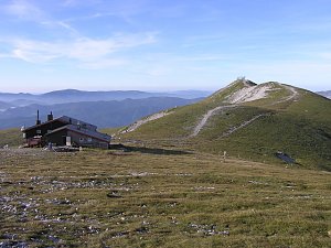
Schönbodenhöhe (1022 m a.s.l., Gutenstein Alps)
Register and log summit

About peak Schönbodenhöhe
 Rakousko
Vrchol Schönbodenhöhe was added here by Jiří Králík.
Help others and .
- Chalet/accommodation
- Stroller access
- Views
- Cable car
- Equipment
- Accessibility
Nearest peaks: Russkogel (1101 m, 1.1 km) Trafelberg (1146 m, 1.5 km) Big Goat's Head (1006 m, 3.7 km)
Routes nearby
Výstup okruhem na Vídeňský Sněžník - Schneeberg
(elevation gain 1500 m, 14 km)
 Hohe Wand - turisticky
 Výstup na špičku rakouské Sněžky - Klosterwappen
(elevation gain 1452 m, )
Routes provided by SvetOutdooru.cz
(elevation gain 1500 m, 14 km)
Hohe Wand - turisticky
Výstup na špičku rakouské Sněžky - Klosterwappen(elevation gain 1452 m, )
Webcams
Gemeinde Muggendorf › South: Unterberg Schutzhaus
(1143 m a.s.l., 3.8 km)
 Gemeinde Ramsau › South
(1291 m a.s.l., 4.4 km)
 Gemeinde Furth an der Triesting › South-West: Enzianhütte Kieneck
(1093 m a.s.l., 5.1 km)
 Gemeinde Ramsau: Golf Club Adamstal Franz Wittmann
(546 m a.s.l., 7 km)

Cameras provided by windy.com
(1143 m a.s.l., 3.8 km)
Gemeinde Ramsau › South(1291 m a.s.l., 4.4 km)
Gemeinde Furth an der Triesting › South-West: Enzianhütte Kieneck(1093 m a.s.l., 5.1 km)
Gemeinde Ramsau: Golf Club Adamstal Franz Wittmann(546 m a.s.l., 7 km)
Sun
| today | tomorrow | day after tomorrow | |
|---|---|---|---|
| Dawn: | 6:00 | 6:01 | 6:03 |
| Sunrise: | 6:32 | 6:33 | 6:35 |
| Sunset: | 16:48 | 16:47 | 16:45 |
| Dusk: | 17:20 | 17:19 | 17:17 |