




Hiking
po, 3.9.2018
 Ukrajina
Logged on Vrcholovka 4x in total. Vrchol Hutyn Tomnatyk was added here by Ostap Zakharko and info was completed by Milan "Hojší" Průžek a Martin Matějka.
Hutyn Tomnatyk (Ukrainian Гутин Томнатик, 2016 m a.s.l.) is a mountain in the Chornohora range in the Transcarpathian region in the southwest of Ukraine. It is located at the end of a short ridge that extends southwest from the main ridge between the peaks of Rebra (2001 m) and Brebeneskul (2035 m). On the eastern side of the mountain lies a basin with the highest situated Ukrainian lake, Brebeneskul. The southern slopes of the mountain descend into the valley of the Brebeneskul stream, which flows out of the lake of the same name.
Access:
A detour from the ridge trail leads to the summit.
There is no chalet on the peak.
Peak is not stroller accessible.
There are views from the peak.
There is no cable car to this peak.
No special equipment is required for this summit.
Peak is freely accessible.
Nearest peaks: Rebra (2001 m, 1.3 km) Brebeneskul (2038 m, 1.7 km) Turkul (1933 m, 3.4 km)
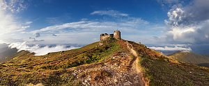 Výstup na nejvyšší ukrajinský vrchol - Hoverlu
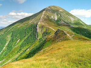 Přechod ukrajinských polonin Maramureš a Černohorská polonina
| today | tomorrow | day after tomorrow | |
|---|---|---|---|
| Dawn: | 6:30 | 6:31 | 6:32 |
| Sunrise: | 7:02 | 7:03 | 7:05 |
| Sunset: | 17:08 | 17:07 | 17:05 |
| Dusk: | 17:40 | 17:39 | 17:37 |




