Pohledecká skála (812 m a.s.l., Žďárské vrchy)
Register and log summit

About peak Pohledecká skála
 Česko
Žďár nad Sázavou (Kraj Vysočina)
Logged on Vrcholovka 29x in total. Vrchol Pohledecká skála was added here by Pája and info was completed by Martin Matějka.
Pohledecká skála is part of challenges: Brněnská výškovnice, Nejhory Českomoravské, Nejhory Žďárských vrchů, The Highest Peaks of Vysočina
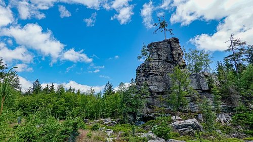
The 8ist peak of the Žďárské vrchy. The highest rock is inaccessible, but the surrounding summit and other accessible rocks are.
- Chalet/accommodation
-
There is no chalet on the peak.
- Stroller access
-
Peak is not stroller accessible.
- Views
-
There are views from the peak.
- Cable car
-
There is no cable car to this peak.
- Equipment
-
No special equipment is required for this summit.
- Accessibility
-
The highest rock is located in the inaccessible area of the I. zone of the Žďárské vrchy Protected Landscape Area, defined by the boundary of the former military zone. The reason for the entry ban is to ensure undisturbed nesting of protected birds.
Nearest peaks: On the Hill (737 m, 1.3 km) Vávrova skála (751 m, 1.3 km) Velryba (692 m, 1.6 km) Olšinky (702 m, 1.7 km) Na kutině (798 m, 1.9 km) Kopečka (695 m, 2 km) Špimberek (705 m, 2.3 km) Metodka (788 m, 2.4 km) Hlavatého kopec (710 m, 2.5 km) Kopeček (822 m, 2.9 km) Rychtářův kopec (708 m, 3.1 km) Michova Hora (666 m, 3.3 km) Bohdalec (801 m, 3.7 km)
Sun
| today | tomorrow | day after tomorrow | |
|---|---|---|---|
| Dawn: | 5:59 | 6:01 | 6:03 |
| Sunrise: | 6:32 | 6:34 | 6:36 |
| Sunset: | 16:46 | 16:44 | 16:42 |
| Dusk: | 17:19 | 17:17 | 17:15 |