Pramen Vltavy (1120 m a.s.l., Šumava)


About peak Pramen Vltavy
 Česko
Logged on Vrcholovka 2x in total. Vrchol Pramen Vltavy was added here by Kris.
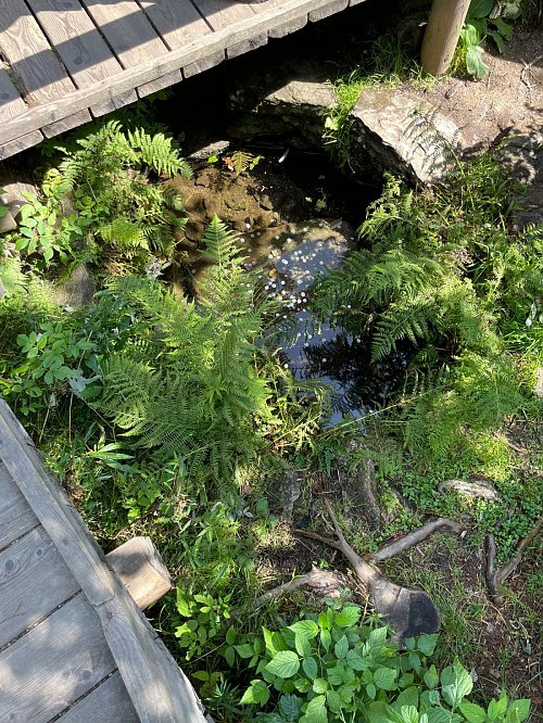
The Vltava Spring is a symbolic spring located about 5.5 km south-southwest of the village of Kvilda in Šumava, 600 meters from the border with Germany. The site is accessible via an asphalt road, along the blue hiking trail, or by bike on cycle route 1041. However, this spring is just a symbolic place; the water is channeled into a stone well through wooden piping that runs beneath the asphalt road. There are more actual springs located high in the inaccessible terrain of the southeastern slope of Černá hora (1316 m above sea level).
- Chalet/accommodation
-
There is no chalet on the peak.
- Stroller access
-
This peak is accessible with a stroller.
- Views
-
There are no views from the peak.
- Cable car
-
There is no cable car to this peak.
- Equipment
-
No special equipment is required for this summit.
- Accessibility
-
Peak is freely accessible.
Nearest peaks: Černá hora (1316 m, 0.9 km) Stráž JZ (1263 m, 1.1 km) Stráž (1308 m, 1.4 km) Siebensteinkopf (1263 m, 1.5 km) Holý vrch (1294 m, 1.6 km) Holý vrch SZ (1173 m, 1.8 km) Farrenberg (1203 m, 2.4 km) Buchmühlkopf (1122 m, 2.5 km) Sandberg (1082 m, 2.8 km) Gabreta (1149 m, 3.2 km) Čertův vrch J (1239 m, 3.4 km) Finsterauer Filz (1065 m, 3.4 km) Streuberg (1034 m, 3.5 km) Čertův vrch (1244 m, 3.6 km)
Routes nearby
Routes provided by SvetOutdooru.cz
Webcams
(1031 m a.s.l., 3.9 km)
 Kvilda: Obec - Chalupa Ve Stráni
( 4.6 km)
 Kvilda
(1042 m a.s.l., 4.8 km)
 Kvilda: I, POI 1
( 4.8 km)
 Kvilda: Horská
(1085 m a.s.l., 4.8 km)
 Kvilda
( 5.1 km)
 Kvilda: Jezerní potok (pohled směr Horská)
(1049 m a.s.l., 5.3 km)
 Filipova Huť
(1101 m a.s.l., 6.7 km)
 Modrava: Filipova Huť, Šumava
( 6.8 km)

Sun
| today | tomorrow | day after tomorrow | |
|---|---|---|---|
| Dawn: | 7:07 | 6:09 | 6:10 |
| Sunrise: | 7:40 | 6:41 | 6:43 |
| Sunset: | 17:59 | 16:57 | 16:56 |
| Dusk: | 18:32 | 17:30 | 17:28 |