Hofertalturm (1883 m a.s.l., Hochschwab)
Register and log summit


About peak Hofertalturm
 Rakousko
Logged on Vrcholovka 1x in total. Vrchol Hofertalturm was added here by Horalka Anička and info was completed by Martin Matějka.
Rock tower
- Chalet/accommodation
-
There is no chalet on the peak.
- Stroller access
-
Peak is not stroller accessible.
- Views
-
There are views from the peak.
- Cable car
-
There is no cable car to this peak.
- Equipment
-
No special equipment is required for this summit.
- Accessibility
-
possibly climbable
Nearest peaks: Kampl (1990 m, 0.7 km) Großer Winkelkogel (1957 m, 1.3 km) Mitterarmkogel SV (1905 m, 1.3 km) Kleiner Winkelkogel (1918 m, 1.5 km) Höllmauer (1949 m, 1.6 km) Östlicher Edelspitz (1867 m, 1.6 km) Schartenspitze (1747 m, 1.6 km) Mittlerer Edelspitz (1876 m, 1.7 km) Westlicher Edelspitz (1883 m, 1.7 km) Stangenkogel (2002 m, 1.8 km) Mitter Höllmauer (1974 m, 1.9 km) Vorder Höllmauer (1979 m, 2 km) Vorder Stangenkogel (1978 m, 2 km) Hinter Severinkogel (2009 m, 2.1 km) Mitteralmturm (1709 m, 2.1 km) Brandlmauer (2020 m, 2.2 km) Ringkarwand (2041 m, 2.2 km) Ringkarwand JZ (2008 m, 2.2 km) Ringkarwand JZ2 (1993 m, 2.2 km) Windgrube S2 (1771 m, 2.2 km) Hutkogel J (1792 m, 2.3 km) Mauerkuppe (1993 m, 2.3 km) Severinkogel (2038 m, 2.3 km) Severinkuppe (2007 m, 2.3 km) Fölzetein (1946 m, 2.4 km) Fölzkogel JV (1961 m, 2.4 km) Wetterkogel V (1771 m, 2.4 km) Hochstein (1741 m, 2.5 km) Mittelkuppe (1982 m, 2.5 km) Rotlacken (2013 m, 2.5 km) Windgrube S (1773 m, 2.5 km) Ringkuppe (1976 m, 2.6 km) Hutkogel (2035 m, 2.7 km) Klein Rotlacken (1963 m, 2.8 km) Nieder Rotlacken (1904 m, 3.1 km) Ringkamp (2153 m, 3.3 km) Windgrube (1809 m, 3.4 km) Hohe Weichsel (2006 m, 3.7 km)
Routes nearby
Routes provided by SvetOutdooru.cz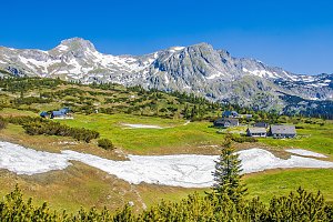


Sun
| today | tomorrow | day after tomorrow | |
|---|---|---|---|
| Dawn: | 6:02 | 6:03 | 6:05 |
| Sunrise: | 6:34 | 6:35 | 6:37 |
| Sunset: | 16:52 | 16:50 | 16:48 |
| Dusk: | 17:23 | 17:22 | 17:20 |