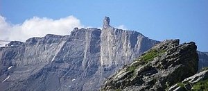
Pic Chaussy (2351 m a.s.l., Bernese Alps)
Register and log summit


About peak Pic Chaussy
 Švýcarsko
Vrchol Pic Chaussy was added here by Milan "Hojší" Průžek.
Elevation: 901 m from the pass, less than 800 m from the parking lot
Ascent time: 2.5 hours
Risk: none
Ascent:
Col des Mosses (1450 m) is a pass between Aigle and Château-d'Oex. It is in an area of the Alps characterized by meadows, lakes, and trees, with surrounding peaks not exceeding 2400 m. Only from the summit of Pic de Chaussy does the rocky and glaciated massif of Diablerets appear directly in front of you. At the Col des Mosses pass, there is an information office where you can get a free map of the area including the route to Chaussy. We can park either at the pass or save 20 minutes of walking by driving as far east and up from the pass as possible (there is a small parking lot at a place called Lioson-d'en Bas). From there, we head to Lake Lac Lioson (tavern). From the picturesque lake, the summit hut is already visible (even though it may not seem like the peak from the lake). From the lake, we first go right to the saddle and then up to the summit. It is important to reach the top for the view of Diablerets. On the way back, you can take the route from the saddle on the opposite side of the lake, leading directly to the parking lot.
Col des Mosses - Lac Lioson 1h (cepr)
lake - summit 1.5 h (cepr)
Interesting fact (skiing):
In 1962, a gondola was built from the Mosses pass to the summit with a stop at Lake Lioson. The cable car was decommissioned in 1987, and the last infrastructure was shut down in 2009 due to protests from Swiss environmentalists who were unhappy with Les Mosses' decision to replace the older cable car.
- Chalet/accommodation
-
There is no chalet on the peak.
- Stroller access
-
Peak is not stroller accessible.
- Views
-
There are views from the peak.
- Cable car
-
There is no cable car to this peak.
- Equipment
-
No special equipment is required for this summit.
- Accessibility
-
Peak is freely accessible.
Routes nearby
(elevation gain 1700 m, 12 km)
 Výstup na Ďáblovu kuželku neboli Sommet des Diablerets ve švýcarských Alpách
(elevation gain 1200 m, 13 km)
Webcams
( 2.5 km)
 Ormont-Dessous: Les Mosses
( 2.5 km)
 Ormont-Dessous: Les Mosses - Vue sur le domaine skiable des Mosses
(1462 m a.s.l., 2.5 km)
 Les Diablerets › South-East: Sommet des Diablerets
(1161 m a.s.l., 3.1 km)
 Ormont-Dessus: Ecole - de Ski Diablerets
( 4.8 km)
 Ormont-Dessous: Les Diablerets - Meilleret
( 4.9 km)
 Ormont-Dessus: Les Diablerets - Les Mazots
( 5.2 km)
 La Forclaz: Vue de Leysin depuis
(1741 m a.s.l., 5.7 km)
 Bretaye: Villars − Petit Chamossaire 360° Panorama
(1763 m a.s.l., 6.2 km)
 Ollon: Villars-sur-Ollon
( 6.2 km)
 Ollon: Villars - Chaux Ronde
( 6.7 km)
 Ollon: Villars-sur-Ollon
( 6.7 km)

Sun
| today | tomorrow | day after tomorrow | |
|---|---|---|---|
| Dawn: | 6:36 | 6:37 | 6:38 |
| Sunrise: | 7:07 | 7:08 | 7:10 |
| Sunset: | 17:23 | 17:21 | 17:20 |
| Dusk: | 17:54 | 17:53 | 17:51 |