





Hiking
pá, 12.4.2024, 13:00
 Itálie
Logged on Vrcholovka 1x in total. Vrchol Monte Sant'Angelo di Cava was added here by Shamot2014.
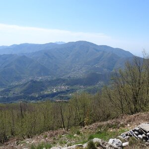
The best access is from the town of Noccera Inferiore, which has a train station and options for buying drinks and food. The ascent can be well aided by the mapy.cz app. From Noccera, the ascent takes about 3 hours, with an elevation gain of around 980 m, and the descent takes about 2 hours, all at a comfortable pace. At the summit, there is a transmitter, and the slopes are covered with thermophilic broadleaf trees, over which ivy climbs. The photo shows the view from the summit towards the eastern part of the Monti Lattari group.
About 800 meters below the summit, there is something between a buffet and a hut, but it is uncertain whether it is always open
Peak is not stroller accessible.
Other peaks of Monti Lattari and the coastal sea
There is no cable car to this peak.
no equipment needed, just take drinks, it can get very hot in summer
Peak is freely accessible.
| today | tomorrow | day after tomorrow | |
|---|---|---|---|
| Dawn: | 5:58 | 6:00 | 6:01 |
| Sunrise: | 6:27 | 6:28 | 6:29 |
| Sunset: | 17:03 | 17:01 | 17:00 |
| Dusk: | 17:31 | 17:30 | 17:28 |