Unternberg (1450 m a.s.l., Chiemgau Alps)
Register and log summit
Weather Unternberg

About peak Unternberg
 Německo
Vrchol Unternberg was added here by Bouřka.
Help others and .
- Chalet/accommodation
-
Unterbergalm.
- Stroller access
-
This peak is accessible with a stroller.
- Views
-
There are views from the peak.
- Cable car
-
A cable car goes to this peak.
- Equipment
-
No special equipment is required for this summit.
- Accessibility
-
Peak is freely accessible.
Nearest peaks: Eisenberg (1488 m, 1.4 km)
Routes nearby
Routes provided by SvetOutdooru.cz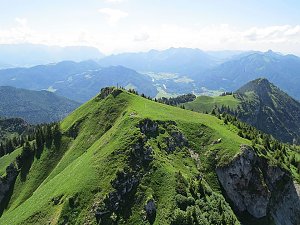
Webcams
Ruhpolding › West
( 0.1 km)
 Ruhpolding › East
(1388 m a.s.l., 0.2 km)
 Ruhpolding: Ferienwohnungen Beim Raffner
(921 m a.s.l., 0.9 km)
 Ruhpolding › North
( 1.3 km)
 Ruhpolding: Chiemgau Arena, Schießstand Chiemgau Arena
( 1.8 km)
 Ruhpolding › East: Eggerschneid
(1001 m a.s.l., 3.1 km)
 Ruhpolding: Rauschberg
(1604 m a.s.l., 3.2 km)
 Ruhpolding › North-West: Rauschberg
(1569 m a.s.l., 3.2 km)
 Ruhpolding › North-West
(1604 m a.s.l., 3.2 km)
 Ruhpolding › South: Golf Club Ruhpolding e.V.
(664 m a.s.l., 3.2 km)
 Ruhpolding
(1615 m a.s.l., 3.4 km)
 Ruhpolding › South: Sonntagshorn
(657 m a.s.l., 3.5 km)
 Ruhpolding: Westernberg
( 3.9 km)
 Ruhpolding › South-West
( 4 km)
 Ruhpolding › South-East
( 4.2 km)
 Ruhpolding › South-East
( 4.2 km)
 Ruhpolding: Bojern
( 4.7 km)
Cameras provided by windy.com
( 0.1 km)
Ruhpolding › East(1388 m a.s.l., 0.2 km)
Ruhpolding: Ferienwohnungen Beim Raffner(921 m a.s.l., 0.9 km)
Ruhpolding › North( 1.3 km)
Ruhpolding: Chiemgau Arena, Schießstand Chiemgau Arena( 1.8 km)
Ruhpolding › East: Eggerschneid(1001 m a.s.l., 3.1 km)
Ruhpolding: Rauschberg(1604 m a.s.l., 3.2 km)
Ruhpolding › North-West: Rauschberg(1569 m a.s.l., 3.2 km)
Ruhpolding › North-West(1604 m a.s.l., 3.2 km)
Ruhpolding › South: Golf Club Ruhpolding e.V.(664 m a.s.l., 3.2 km)
Ruhpolding(1615 m a.s.l., 3.4 km)
Ruhpolding › South: Sonntagshorn(657 m a.s.l., 3.5 km)
Ruhpolding: Westernberg( 3.9 km)
Ruhpolding › South-West( 4 km)
Ruhpolding › South-East( 4.2 km)
Ruhpolding › South-East( 4.2 km)
Ruhpolding: Bojern( 4.7 km)
Sun
| today | tomorrow | day after tomorrow | |
|---|---|---|---|
| Dawn: | 7:10 | 6:11 | 6:12 |
| Sunrise: | 7:41 | 6:43 | 6:44 |
| Sunset: | 18:05 | 17:03 | 17:02 |
| Dusk: | 18:37 | 17:35 | 17:33 |