

Hiking, 11 km
6.1.2023

Itálie
Logged on Vrcholovka 2x in total. Vrchol Castelluccio di Pisciotta was added here by Milan "Hojší" Průžek.
Length: 13 km
Elevation: 175-701 m a.s.l.
Elevation gain: 500 m
Difficulty: moderate
Duration: 4 hours 30 minutes
The circular trail leads through the shrubs of the hills near Pisciotta, revealing the sometimes rugged nature of the area. Small mule paths, steep ascents, and descents on protruding rocks are dominated by vegetation that seems to be revived by the desire to reclaim every space. We follow the trekking experience narrated by Francesco D'Amato, the councilor for culture.
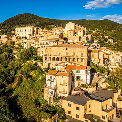
The route has its starting and ending point at the "R. Pinto" square of the medieval village of Pisciotta. We head towards Palinuro, and after just 200 meters, we begin the ascent leading to "Riùly".
The starting scenery is typical for this area: "olive trees, olive trees, always olive trees, olive trees like sheep in flocks," said Ungaretti in his "Journey to the South". In fact, the typical centuries-old olive groves of the "pisciottana" variety are interrupted only by colorful gardens scattered throughout the village, perched on a hill overlooking the sea (175 m a.s.l.).
After just 1 km, we encounter the first wonderful attraction: an ancient water mill, now out of use. You reach the complex, truly remarkable in size, by crossing the stream "flowers" via a magnificent stone bridge "humpbacked", an authentic architectural masterpiece.
We continue along the path, leaving "mill alla riùla" to the left and climbing up an initially rocky ascent, characterized by the ecstatic scent of low Mediterranean shrubs, rich in myrtle, mastic, cistus, St. John's wort, laurel, broom.
We travel another kilometer, and the scenery radically changes: the pleasant background provided by the roar of the "Flowers" stream leaves us as we pass to the opposite bank of the hill. Here, on the side less exposed to sunlight, the vegetation thickens, and thus poplars, holm oaks, alders, and further chestnuts arch over our heads, making the gentle ascent pleasant and truly not tiring.
The path is always accompanied by birds of various species, especially numerous are the hawks, blackbirds, crows; But we are certainly captivated by the spring colors, immensely diverse and captivating: from the yellow broom to the white of flowering cistus, from the shimmering green of tall poplars to the dark and dense green of lentisk thickets. Very beautiful.
After the first hour of walking, we reach an altitude of about 450 meters above sea level at the site "Rungi", where the scene changes again, for the third time. Suddenly, the path in the shade of chestnuts leads to a wide and flat road, dotted with rural houses and enormous vineyards.
We begin to have wider views, which project into very evocative panoramas.
A quarter of an hour on the flat, just to rest for a moment and enjoy the path from above, and we find ourselves at "Piano del campo", where an arrow indicates the beginning of the ascent that will lead to the hill "Castelluccio".
We continue without particular effort due to the gentleness of the slope (after all, we will climb from an altitude of 175 m a.s.l. to 701 m a.s.l. in 2.5 hours and about 7 km).
Along the way, space begins to create a completely dominant botanical species: the strawberry tree. This plant, rich in delicious fruit in winter, excellent for jams, is commonly associated with a small shrub typical of the Mediterranean. Here we find trees up to twelve meters high, forming bands of real forests!
In the undergrowth, then, due to the season, we begin to see strawberry fields, and thus travel times are longer, without regret from anyone.
In fact, it is hard to imagine a season when nature, which is the highest expression of comfort and wealth in these areas, does not give respectful and attentive visitors delicious fruits: blackberries, strawberries, chestnuts, walnuts, cherries, apricots, figs, etc.
Another rich hour has passed, and we reach the foot of the long-awaited hill or equipped area "Castelluccio".
Here we stop for lunch, but we easily find the incentive to continue a few hundred meters further until we reach the summit.
It is the apotheosis of all the views we have occasionally glimpsed. From Castelluccio, you can see practically the whole Cilento: inside is the view from Monte Stelly (1131 m) to Monte Bulgheria (1226 m), through Monte Gelbison (1701 m) and Monte Cervati (1998 m); at sea, the view can range from Capo Palinuro to Punta Licosa. The villages of inner Cilento are at our feet, as well as the wide valleys of the Lambro and Mingardo rivers.
In short, it takes a good ten minutes to focus on all the elements of the landscape that has opened up before our eyes!
We barely notice the ruins of a military base (III century B.C.) of the ancient and very important Greek city of Elea (the homeland of Parmenides and Zeno, the cradle of Western philosophy).
Now we are ready for a rich lunch break.
After the time needed to remove the fatigue with typical Cilento products, we depart towards the north. It seems that the path, which will characterize the third hour of walking, accompanies digestion and restores the rhythm of walking.
In an hour, we descend from 701 m a.s.l. to 633 m a.s.l., practically the plateau. After all, the topographic name "le serre" tells us that we are walking along the ridge of a panoramic and lush hill.
Now we are surrounded only by tall chestnut groves. The path is initially wide and sunny, then gives way to a narrower path and even submerged in dense vegetation. This ancient sheep path of robbers and farmers is the most impressive and pleasant part of the entire route.
We would hardly realize that we have reached the beginning of the descent if a flash of light had not suddenly opened to our left.
We have reached the panoramic point "Chestnut Water".
In the deepest strawberry forest, which has replaced the chestnut groves at about 600 meters above sea level, a nearly suspended large rock resembling a trampoline spreads in the void of the ridge, which steeply descends into the valley. Below, the scenery above the village of Pisciotta projected onto the vast expanse of sea beneath it is simply breathtaking.
It is hard to start again, and the quick pace of the final descent makes this task only slightly easier. We slowly return to the anthropized environment (< 450 m a.s.l.) and immerse ourselves back into the centuries-old olive groves and orchards that do not escape our desire to taste typical products again!
As the fourth hour of walking strikes, we arrive at the panoramic point S. Bernardino, a key intersection between the villages of Pisciotta and Rodio and a place already visited by Greek monks of the Basilian worship, who built a small monastery (VIII century A.D.).
From here, the cobbled path, unfortunately mostly torn, descends steeply...
There is no chalet on the peak.
Peak is not stroller accessible.
There is no cable car to this peak.
No special equipment is required for this summit.
Peak is freely accessible.
| today | tomorrow | day after tomorrow | |
|---|---|---|---|
| Dawn: | 6:14 | 6:15 | 6:16 |
| Sunrise: | 6:43 | 6:44 | 6:45 |
| Sunset: | 16:43 | 16:42 | 16:41 |
| Dusk: | 17:12 | 17:11 | 17:10 |