
Hiking, 11 km
15.5.2026 to 17.5.2026
 Česko
Plzeň-město (Plzeňský kraj)
Logged on Vrcholovka 10x in total. Vrchol Andrejšky was added here by Bouřka and info was completed by Krtek.
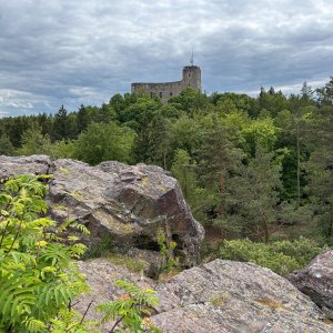
According to the local information board, this is a 300-meter long and 20-meter wide basalt rock formation. Thus, a 300-meter rocky ridge, or a series of rocks, each with sufficient prominence, and many of which can be climbed by regular climbing. The photo shows the upper beginning of the ridge. Access is either via a loop through the other peaks of Radyňský forest or from the end of Andrejšky street in Starý Plzenec, which is literally just a few meters away. No views.
There is no chalet on the peak.
Peak is not stroller accessible.
There are no views from the peak.
There is no cable car to this peak.
No special equipment is required for this summit.
Peak is freely accessible.
Nearest peaks: Andrejšky S (448 m, 0.2 km) Na Andrejškách (502 m, 0.4 km) Svatební stěna (528 m, 0.5 km) Velká skála Z (544 m, 0.5 km) Velká skála (555 m, 0.6 km) Velká skála SZ (547 m, 0.6 km) Karlova pěst (521 m, 0.7 km) Radyně S (549 m, 0.7 km) Na Hořejším Černicku (458 m, 0.8 km) Radyně (567 m, 0.8 km) Na Hořejším Černicku S (440 m, 0.9 km) Rozárka (433 m, 1.1 km) Ostrá hůrka (413 m, 1.9 km) Za Lesem (490 m, 2.1 km) Hůrka JZ (427 m, 2.4 km) Vinařovic vršek (473 m, 2.5 km) Hůrka (431 m, 2.8 km) In the Borders NW (473 m, 3 km) V meznicích (469 m, 3 km) In the Borders Z (468 m, 3.1 km) Na Kocandě (459 m, 3.1 km) Na Škalkách (511 m, 3.2 km)
| today | tomorrow | day after tomorrow | |
|---|---|---|---|
| Dawn: | 7:07 | 7:09 | 6:10 |
| Sunrise: | 7:40 | 7:42 | 6:43 |
| Sunset: | 18:00 | 17:58 | 16:56 |
| Dusk: | 18:33 | 18:31 | 17:29 |