



Hiking
st, 10.8.2016, 17:39
 Turecko
Logged on Vrcholovka 3x in total. Vrchol Nemrut Dağı - Kráter was added here by James and info was completed by Martin Matějka.
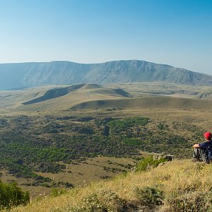
The summit of Nemrut was blown off during an eruption, creating a massive caldera with a diameter of 7 km. On the western side, this caldera is filled with one of the largest volcanic lakes on Earth, which is 155 m deep and filled with cold water. Inside the crater, there are two additional smaller lakes. To the north lies Ilıgöl, which is warm according to its name. Hot water and steam vents are located along its edges, where the water temperature in the lake can reach up to 80 °C. Ilıgöl has a diameter of 500 m and a depth of 7 - 8 m. The second lake is called Küçükgöl (translated: Small Lake) and is located east of the volcanic lake.
There is no chalet on the peak.
This peak is accessible with a stroller.
There are views from the peak.
There is no cable car to this peak.
No special equipment is required for this summit.
Peak is freely accessible.
Nearest peaks: Nemrut (2916 m, 2 km)
| today | tomorrow | day after tomorrow | |
|---|---|---|---|
| Dawn: | 6:08 | 6:09 | 6:10 |
| Sunrise: | 6:35 | 6:36 | 6:37 |
| Sunset: | 17:13 | 17:12 | 17:11 |
| Dusk: | 17:41 | 17:40 | 17:38 |

