Aiguille de Chambeyron (3412 m a.s.l., Kottické Alpy)
Register and log summit
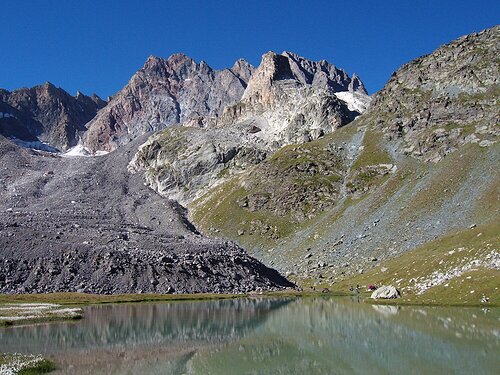

About peak Aiguille de Chambeyron
 Francie
Peak information here was completed by Tomáš Bublan.
FR
Difficulty I/A-04.I-A
- Chalet/accommodation
-
There is no chalet on the peak.
- Stroller access
-
Peak is not stroller accessible.
- Views
-
There are views from the peak.
- Cable car
-
There is no cable car to this peak.
- Equipment
- Accessibility
-
Peak is freely accessible.
Nearest peaks: Brec de Chambeyron (3389 m, 2.2 km)
Routes nearby
Okruh kolem vrcholu Brec de Chambeyron v Provance
(elevation gain 1500 m, 15 km)
 Výstup na Tete de la Frema Túra přes jezero devíti barev Lac des Neuf Couleurs
(elevation gain 1300 m, 18 km)
Túra v podobě přechodu masívu Chambeyron v Provance
(elevation gain 1300 m, 20 km)
Túra pod Horu Svatého pramene v NP Queyras
(elevation gain 1200 m, 11 km)
Routes provided by SvetOutdooru.cz
(elevation gain 1500 m, 15 km)
Výstup na Tete de la Frema Túra přes jezero devíti barev Lac des Neuf Couleurs(elevation gain 1300 m, 18 km)
Túra v podobě přechodu masívu Chambeyron v Provance(elevation gain 1300 m, 20 km)
Túra pod Horu Svatého pramene v NP Queyras(elevation gain 1200 m, 11 km)
Sun
| today | tomorrow | day after tomorrow | |
|---|---|---|---|
| Dawn: | 6:33 | 6:34 | 6:36 |
| Sunrise: | 7:03 | 7:04 | 7:06 |
| Sunset: | 17:29 | 17:27 | 17:26 |
| Dusk: | 17:59 | 17:57 | 17:56 |