





Hiking
st, 24.7.2024, 10:20
 Itálie
Logged on Vrcholovka 5x in total. Vrchol Monte Cernera Cima Nord was added here by Aleš Krumphanzl and info was completed by Aleš Krumphanzl, Martin Matějka, Jiří Králík a Jan Blažej.
Help others and .
There is no chalet on the peak.
Peak is not stroller accessible.
There are views from the peak.
There is no cable car to this peak.
On the normal route, there are three short sections with steel cables. It can be done without, but those who are unsure should secure themselves.
Peak is freely accessible.
Nearest peaks: Monte Cernera Cima Nord SV (2662 m, 0.2 km) Cima Loschiesuoi (2626 m, 0.3 km) Monte Verdal SV (2485 m, 0.5 km) Monte Verdal (2491 m, 0.6 km) Col Piombin (2313 m, 1.2 km) Punta di Zonia V (2244 m, 1.3 km) Punta di Zonia (2282 m, 1.5 km) Ponta Lastoi de Formin (2657 m, 1.7 km) Monte Mondeval (2455 m, 2 km) Ra Gusela (2595 m, 2.6 km) Nuvolau JV (2529 m, 3 km) Nuvolau (2575 m, 3.2 km)
 Výstup na třítisícovku Tofana di Rozes se psem
 Trek válečnou stezkou Via Lagazuoi v Dolomitech
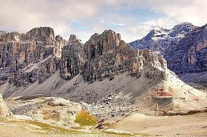
 Colle Santa Lucia › South
 Selva di Cadore: Santa Fosca
 Selva di Cadore: Bar Bianco di Gioacchino a S. Fosca (BL)
 Colle: Averau
 Selva di Cadore › South: Seggiovie Fertazza – Cima Fertazza
 Colle Santa Lucia › North-West: Rifugio Averau
 Cortina d'Ampezzo: Cortina d’Ampezzo, 5 Torri
 Cortina d'Ampezzo: Cinque Torri
 Alleghe: Selva di Cadore - Pescul
 Alleghe: Fertazza
 Selva di Cadore
 Alleghe: Col dei Baldi
 Cortina d'Ampezzo: Col Gallina
 Alleghe: Piani di Pezze
 Cortina d'Ampezzo › South-East
 Pocol: Tofana die Rozes, Tofana die Mezzo
 Passo di Falzarego › East
 Cortina d'Ampezzo: Lagazuoi − Tofane

| today | tomorrow | day after tomorrow | |
|---|---|---|---|
| Dawn: | 6:16 | 6:17 | 6:19 |
| Sunrise: | 6:47 | 6:48 | 6:50 |
| Sunset: | 17:03 | 17:02 | 17:00 |
| Dusk: | 17:34 | 17:33 | 17:31 |


