Villányi Mountain
| Highest peak | Szársomlyó (442 m a.s.l.) |
|---|---|
| Most prominent peak | Szársomlyó (442 m a.s.l., prominence 282 m) |
| Parent unit | Zadunajské pahorkatiny |
| Main peaks | Total 5 |
| Most popular peaks | Tenkes (409 m a.s.l.), Black Mountain (341 m a.s.l.), Szársomlyó (442 m a.s.l.), Kopasz-hegy (267 m a.s.l.), Csukma Mountain (343 m a.s.l.) |

| Name | Elevation | ||||
|---|---|---|---|---|---|
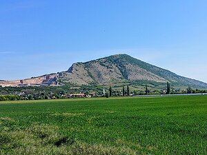
|
Szársomlyó | 442 m a.s.l. | Villányi Mountain | 282 m | hlavní vrchol |

|
Tenkes | 409 m a.s.l. | Villányi Mountain | 213 m | hlavní vrchol |

|
Csukma Mountain | 343 m a.s.l. | Villányi Mountain | 37 m | hlavní vrchol |

|
Black Mountain | 341 m a.s.l. | Villányi Mountain | 117 m | hlavní vrchol |
|
Kopasz-hegy | 267 m a.s.l. | Villányi Mountain | 67 m | hlavní vrchol |