Cycling, 40 km
26.7.2026
 Česko
Blansko (Jihomoravský kraj)
Logged on Vrcholovka 23x in total. Vrchol Škatulec was added here by Tesi.
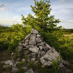
In the vast forests south of Boskovice, roughly halfway between Újezd and Valchov, lies the hill Škatulec (656 m), also known as Na Babylóně. A green hiking trail leads from Boskovice there, continuing towards Kuničky. Škatulec is also the name of the entire geomorphological area (part of the Adamovská vrchovina subunit within the Drahanská vrchovina). The highest point of the Škatulec area is Holíkov (665 m) at the eastern tip of the block. The boundary of the cadasters and the boundaries of the forest properties – the former estates of Boskovice and Rájec – pass over the summit of Škatulec (656 m). Occasionally, one can still find old boundary stones in the forests marked with the initials HB or HR. The strange name Škatulec is likely related to the work of surveyors in the past. The local geodetic point was probably marked by some wooden structure, which the locals referred to as “škatule” due to its unusual appearance. The summit was likely treeless at that time, so there was no need to build a classic wooden triangulation tower.
There is no chalet on the peak.
Peak is not stroller accessible.
There are views from the peak.
There is no cable car to this peak.
No special equipment is required for this summit.
Peak is freely accessible.
Nearest peaks: Škatulec V (665 m, 0.9 km) Holíkov (667 m, 1.2 km) Lipka (563 m, 2.1 km) Rájecký les (642 m, 2.2 km) Hradský kopec (487 m, 3.4 km)
| today | tomorrow | day after tomorrow | |
|---|---|---|---|
| Dawn: | 6:54 | 6:55 | 5:57 |
| Sunrise: | 7:27 | 7:28 | 6:30 |
| Sunset: | 17:48 | 17:46 | 16:44 |
| Dusk: | 18:20 | 18:18 | 17:17 |