Trojačka rozcestí (618 m a.s.l., Moravian-Silesian Beskydy Mountains)



About peak Trojačka rozcestí
 Česko
Logged on Vrcholovka 1x in total. Vrchol Trojačka rozcestí was added here by Monika Ptáčková.
Help others and .
- Chalet/accommodation
- Stroller access
- Views
-
There are views from the peak.
- Cable car
-
There is no cable car to this peak.
- Equipment
-
No special equipment is required for this summit.
- Accessibility
-
Peak is freely accessible.
Nearest peaks: Oprchlice (639 m, 0.2 km) Oprchlice JZ (627 m, 0.5 km) Trojačka (709 m, 1.2 km) Bzovka (448 m, 1.3 km) Vlčí vrch (546 m, 1.5 km) Žernový (492 m, 1.5 km) Budička (508 m, 2 km) Horní kout (398 m, 2.1 km) Vyhlídka školní lavice (373 m, 2.5 km) Nad Zrzávkou (449 m, 2.6 km) Černý kopeček (393 m, 3 km) Včelín (432 m, 3.2 km) Břízek (380 m, 3.3 km) Zadní kopec (417 m, 3.7 km)
Routes nearby
Routes provided by SvetOutdooru.cz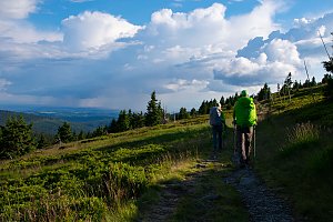
Mountain chalets
Webcams
Cameras provided by windy.com

Sun
| today | tomorrow | day after tomorrow | |
|---|---|---|---|
| Dawn: | 5:58 | 5:59 | 6:01 |
| Sunrise: | 6:31 | 6:33 | 6:34 |
| Sunset: | 16:31 | 16:29 | 16:28 |
| Dusk: | 17:04 | 17:03 | 17:01 |