

Hiking, 4 km
15.11.2025
 Česko
Třebíč (Kraj Vysočina)
Logged on Vrcholovka 7x in total. Vrchol Svatý Vít was added here by Jiřina and info was completed by Martin Matějka a Jiřina.
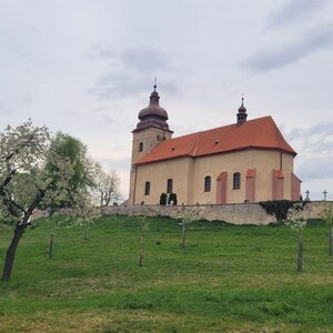
A very inconspicuous (URBEX) structure that was once a chapel and later a summer house, has been abandoned since 1840. Cycle path 5103 runs along the contour about 15 summit meters below.
The easiest access is from the southeast side along a path paved with panels up to the water reservoir. From there, a worn path leads around its fence for about 50 meters.
The summit is marked by a stone approximately 12 meters southeast of the building.
There is no chalet on the peak.
This peak is accessible with a stroller.
There are no views from the peak.
There is no cable car to this peak.
No special equipment is required for this summit.
Peak is freely accessible.
Nearest peaks: Kozí hora (526 m, 0.7 km) Lukovská hora (530 m, 1.2 km) Holý kopec (580 m, 1.5 km) Brdo (580 m, 2.9 km) Heřmanský kopec (470 m, 3.3 km)
| today | tomorrow | day after tomorrow | |
|---|---|---|---|
| Dawn: | 6:05 | 6:06 | 6:08 |
| Sunrise: | 6:37 | 6:39 | 6:41 |
| Sunset: | 16:43 | 16:41 | 16:39 |
| Dusk: | 17:16 | 17:14 | 17:12 |