Helags (Helagsfjället) (1797 m a.s.l., Scandinavian Mountains)
Register and log summit
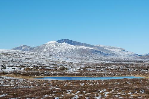

About peak Helags (Helagsfjället)
 Švédsko
Vrchol Helags (Helagsfjället) was added here by Milan "Hojší" Průžek and info was completed by Milan "Hojší" Průžek.
Helags, also known as Helagsfjället, is a mountain massif (fell) in the Scandinavian Mountains, located in the Swedish municipality of Berg. The main peak, Helagsstöten, rises to 1797 m above sea level, making it the highest point in the province of Härjedalen and the entire part of Sweden south of the Arctic Circle. The ridge has steep walls, and on its eastern slope lies the southernmost glacier in Sweden, called Helagsgaciären.
The name comes from the Old Norse word "helig" (sacred). The mountain was first ascended in 1868 by geologist Edvard Erdmann with two guides from the nearby village of Ljungdalen. In 1897, a tourist cabin, Helagsstugorna, was built at an altitude of around one thousand meters, operated by the Svenska Turistföreningen.
- Chalet/accommodation
-
There is a chalet on the peak.
- Stroller access
-
Peak is not stroller accessible.
- Views
-
There are views from the peak.
- Cable car
-
There is no cable car to this peak.
- Equipment
- Accessibility
Webcams
Cameras provided by windy.com
Sun
| today | tomorrow | day after tomorrow | |
|---|---|---|---|
| Dawn: | 6:48 | 6:50 | 6:53 |
| Sunrise: | 7:37 | 7:40 | 7:43 |
| Sunset: | 16:10 | 16:07 | 16:04 |
| Dusk: | 16:59 | 16:56 | 16:54 |