Sarektjåkkå - Sydtoppen (2023 m a.s.l., Scandinavian Mountains)
Register and log summit
Weather Sarektjåkkå - Sydtoppen

About peak Sarektjåkkå - Sydtoppen
Švédsko
Vrchol Sarektjåkkå - Sydtoppen was added here by Milan "Hojší" Průžek and info was completed by Martin Matějka.
Sarektjåkkå (2089 m a.s.l.) is a mountain in the Scandinavian Mountains. It is located in northern Sweden in the Norrbotten region within the municipality of Jokkmokk. The mountain lies near the eastern border of Sarek National Park, about 23 km southwest of the settlement of Suorva. With an elevation of 2089 m, it is the second highest mountain in Sweden (third if the southern peak of Kebnekaise is counted as a separate mountain).
Sarektjåkkå has four peaks:
Stortoppen - 2089 m
Nordtoppen - 2056 m
Sydtoppen - 2023 m
Buchttoppen - 2010 m
- Chalet/accommodation
- Stroller access
-
Peak is not stroller accessible.
- Views
-
There are views from the peak.
- Cable car
-
There is no cable car to this peak.
- Equipment
-
Special equipment is required for this summit.
- Accessibility
Nearest peaks: Sarektjåkkå - Buchttoppen (2010 m, 0.7 km) Sarektjåkkå (2089 m, 0.9 km) Sarektjåkkå Nordtoppen (2056 m, 1.3 km)
Routes nearby
(elevation gain 3800 m, 100 km)
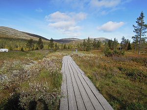 K deltě řeky Rapa ve švédském NP Sarek
(50 km)
Sun
| today | tomorrow | day after tomorrow | |
|---|---|---|---|
| Dawn: | 7:15 | 7:19 | 7:22 |
| Sunrise: | 8:23 | 8:27 | 8:32 |
| Sunset: | 14:42 | 14:37 | 14:33 |
| Dusk: | 15:49 | 15:46 | 15:43 |