Meridian (870 m a.s.l., Jizera Mountains)
Register and log summit

About peak Meridian
Česko
Liberec (Liberecký kraj)
Logged on Vrcholovka 1x in total. Vrchol Meridian was added here by Martin Matějka and info was completed by Martin Matějka.
Meridian is part of challenge: Highest Peaks of the Jizera Mountains
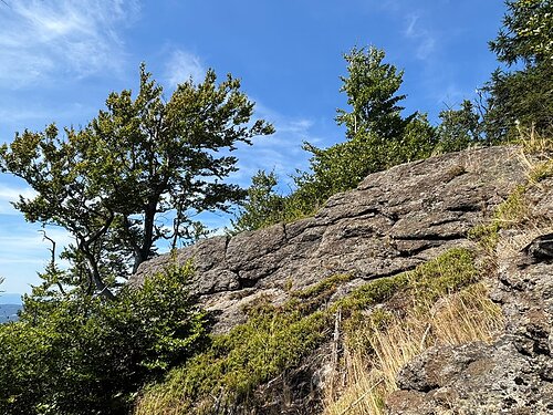
The main peak of Poledník, which has recently been revealed on more accurate maps (ČÚZK and Mapy.cz) and which exceeds the northern peak by 5 meters. A wild rocky peak, with very steep southern and eastern slopes and a fabulous view of Ještěd (and Olivetská hora, Ptačí kupy...). Inaccessible, in the territory of the Jizera Mountains Beech Forests National Park, but still quite easily accessible by a well-trodden path from the saddle with the northern peak.
- Chalet/accommodation
-
There is no chalet on the peak.
- Stroller access
-
Peak is not stroller accessible.
- Views
-
great southwest to southeast, partial east
- Cable car
-
There is no cable car to this peak.
- Equipment
-
No special equipment is required for this summit.
- Accessibility
-
National Park Jizera Mountains Beech Forests
Nearest peaks: Poledník S (865 m, 0.1 km) Poledník V1 (846 m, 0.3 km) Poledník V2 (843 m, 0.7 km) Zlomený kámen (704 m, 1 km) Sviní kámen (689 m, 1.1 km) Zadní Divočák (864 m, 1.1 km) Broken Stone Z (690 m, 1.2 km) Závory (757 m, 1.2 km) Olivetská hora SZ (817 m, 1.3 km) Ostrý hřeben (714 m, 1.4 km) Mlaka (450 m, 1.6 km) Sharp corner (638 m, 1.6 km) Svinské čelo (797 m, 1.6 km) Olivetská hora (886 m, 1.7 km) Vřesoviště (662 m, 2.2 km) Olivetská hora J (842 m, 2.7 km) Back (845 m, 2.9 km) Above Šolc's Pond (461 m, 3.6 km)
Routes nearby
Routes provided by SvetOutdooru.cz


Sun
| today | tomorrow | day after tomorrow | |
|---|---|---|---|
| Dawn: | 6:34 | 6:35 | 6:37 |
| Sunrise: | 7:10 | 7:11 | 7:13 |
| Sunset: | 16:17 | 16:15 | 16:14 |
| Dusk: | 16:52 | 16:51 | 16:50 |