Upper Borovnyák (947 m a.s.l., Bukové hory)
Register and log summit
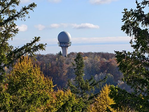

About peak Upper Borovnyák
 Maďarsko
Logged on Vrcholovka 1x in total. Vrchol Upper Borovnyák was added here by Jiří Králík and info was completed by Jiří Králík.
Upper Borovnyák is part of challenge: TOP 10 Hungary
NATO radar. The summit marker is at the upper lift station, where there are views of the High Tatras. The radar itself is fenced and guarded by a camera system.
- Chalet/accommodation
-
There is no chalet on the peak.
- Stroller access
-
Peak is not stroller accessible.
- Views
-
There are no views from the peak.
- Cable car
-
There is no cable car to this peak.
- Equipment
-
No special equipment is required for this summit.
- Accessibility
-
NATO radar.
Nearest peaks: Kis-Balvány (950 m, 1 km) Borovnyák-tető (870 m, 1.1 km) Veres-sar-berc (920 m, 1.2 km) Bem apó-szikla (829 m, 1.3 km) Boulders (957 m, 1.3 km) Nagy-Csipkés (878 m, 1.3 km) Pipis-hegy (934 m, 1.3 km) Nyárjú-hegy (893 m, 1.7 km) Kerek-hegy (824 m, 1.9 km) Smoke-stone-bérc (924 m, 1.9 km) Kis-Csipkés (804 m, 2 km) Taró-fő (784 m, 2 km) Fodor-hegy (936 m, 2.1 km) The Strong István Nagy (938 m, 2.2 km) Verebec-vár-bérc (663 m, 2.3 km) Alsó-Nyárjú-hegy (813 m, 2.4 km) Semi-legs (909 m, 2.4 km) Kis-sar-berc (925 m, 3 km) Kis-mező-hegy (841 m, 3.1 km) Zobó hegyese (592 m, 3.5 km)
Sun
| today | tomorrow | day after tomorrow | |
|---|---|---|---|
| Dawn: | 5:49 | 5:50 | 5:52 |
| Sunrise: | 6:21 | 6:23 | 6:24 |
| Sunset: | 16:21 | 16:20 | 16:18 |
| Dusk: | 16:54 | 16:52 | 16:51 |