



Hiking
st, 29.10.2025, 12:24
 Maďarsko
Logged on Vrcholovka 1x in total. Vrchol Double-breasted S was added here by Jiří Králík and info was completed by Jiří Králík.
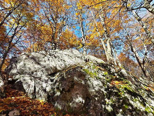
Northern promontory with limestone rock formation.
There is no chalet on the peak.
Peak is not stroller accessible.
There are no views from the peak.
There is no cable car to this peak.
No special equipment is required for this summit.
Peak is freely accessible.
Nearest peaks: Szilvási-kő (961 m, 0.2 km) Istállós-kő (959 m, 0.5 km) Ispán-hegy (912 m, 0.6 km) Kukucsó Hill (938 m, 0.8 km) Red mud hill (951 m, 0.8 km) Kis-hegy (935 m, 0.9 km) Kőris-hegy (945 m, 0.9 km) Viragos-sár-hegy (955 m, 0.9 km) Kőrös-bérc (956 m, 1.1 km) Upper-Great-Vero (728 m, 1.2 km) Nagy-Kopasz (907 m, 1.3 km) Kis-tanya (916 m, 1.6 km) Alsó-Nagy-verő (706 m, 1.7 km) Sima-hegy (876 m, 1.7 km) Black-Sar-Bérc (937 m, 1.8 km) Leany-hill (893 m, 1.8 km) Huta-berc (923 m, 1.9 km) Kalman Hill (875 m, 1.9 km) Küllő-hegy (902 m, 1.9 km) Büszkes-hegy (954 m, 2.2 km) Kis-sar-berc (925 m, 2.2 km) Ölyves-völgyfő (934 m, 2.3 km) Round-meadow-head (882 m, 2.4 km) Dog-stone (865 m, 2.6 km) Tar-stone (960 m, 2.6 km) Almad-hegy (861 m, 2.7 km) The Strong István Nagy (938 m, 2.8 km) Őr-kő (885 m, 3.1 km) Kuklya-hegyese (711 m, 3.2 km) Sharp stone (857 m, 3.2 km) Kecskor-hegyese (692 m, 3.4 km) Lambot (642 m, 3.7 km)
| today | tomorrow | day after tomorrow | |
|---|---|---|---|
| Dawn: | 5:49 | 5:50 | 5:52 |
| Sunrise: | 6:21 | 6:23 | 6:24 |
| Sunset: | 16:21 | 16:20 | 16:18 |
| Dusk: | 16:54 | 16:52 | 16:51 |