



Hiking, 3 km
19.6.2025
 Polsko
Logged on Vrcholovka 1x in total. Vrchol Miedzianka was added here by Milda.
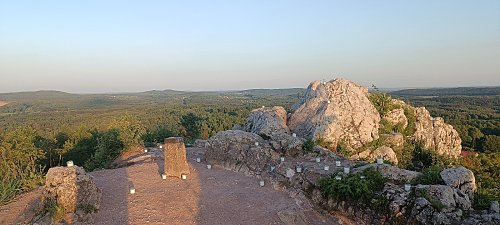
Miedzianka (356 m a.s.l.) is part of the Crown of the Holy Cross Mountains. The badge "Crown of the Holy Cross Mountains" is a regional badge of PTTK Świętokrzyskie branch in Kielce. [https://kgs.info.pl/] It is the highest point of the Miedzianka Hills, located in the western part of the Chęciny Mountains. It is composed of limestone from the Middle and Upper Devonian. The name of the hill refers to the copper ores found here. When viewed from the north, Miedzianka somewhat resembles the Tatra Giewont, and is sometimes jokingly referred to as the “Swiętokrzyski Giewont.” In 1958, the entire Miedzianka massif was placed under the protection of a reserve. The then-established nature reserve “Góra Miedzianka” protects not only surface rock formations, plants, and animals, but also traces of mining from centuries ago and karst phenomena. The beginnings of the exploitation of the deposits here are unknown, possibly dating back to Roman times. During the interwar period, Roman coins were found on Miedzianka, and in 1902, old pavements were discovered at a depth of 60 m. The first written mention of Miedzianka dates back to 1487, when Jan Karaś, the manager of the mine in Chęciny, received permission from King Casimir IV Jagiellon to establish a copper smelter in nearby Polichno. In 2008, the municipality of Chęciny established a Museum of Ore Mining in the building of the former school in Miedzianka. It collects and exhibits traces of mining. The minerals and tools gathered here testify to the rich history and significance of this place. Beneath Miedzianka Mountain, there are about 4 km of shafts and tunnels that are not accessible to tourists. A yellow hiking trail leads over Miedzianka, the Julius Braun Trail from Wierna Rzeka to Chęciny. From the museum, a green geological trail leads to the summit, unfortunately already erased in many places.
There is no chalet on the peak.
Peak is not stroller accessible.
There are views from the peak.
There is no cable car to this peak.
No special equipment is required for this summit.
Peak is freely accessible.
Nearest peaks: Grząby Bolmińskie (330 m, 3.2 km)
| today | tomorrow | day after tomorrow | |
|---|---|---|---|
| Dawn: | 5:46 | 5:47 | 5:49 |
| Sunrise: | 6:20 | 6:21 | 6:23 |
| Sunset: | 16:24 | 16:23 | 16:21 |
| Dusk: | 16:58 | 16:57 | 16:55 |
