



Hiking
st, 17.7.2024, 14:13

 Česko
Logged on Vrcholovka 3x in total. Vrchol Ondřejník - tur. chata was added here by Šimi.
Help others and .
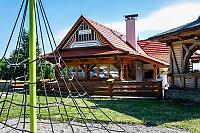
There is a chalet on the peak.
This peak is accessible with a stroller.
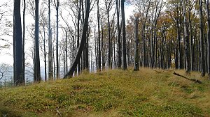
There are views from the peak.
There is no cable car to this peak.
No special equipment is required for this summit.
Nearest peaks: Ondřejník (890 m, 0.6 km) Sovjanka (565 m, 1.7 km) Suchá (900 m, 1.7 km) Stanovec (899 m, 2.3 km) Horečka (446 m, 2.8 km) Velká Horečka (413 m, 3 km) Maliniska (439 m, 3.1 km) Opálená (641 m, 3.2 km) Matějův čupek (447 m, 3.3 km) Skalka (964 m, 3.3 km) Kozlovická hora V (561 m, 3.7 km)
| today | tomorrow | day after tomorrow | |
|---|---|---|---|
| Dawn: | 6:04 | 6:06 | 6:07 |
| Sunrise: | 6:38 | 6:40 | 6:41 |
| Sunset: | 16:21 | 16:20 | 16:18 |
| Dusk: | 16:55 | 16:54 | 16:52 |