Vanil Noir (2388 m a.s.l., Freiburg Alps)
Register and log summit
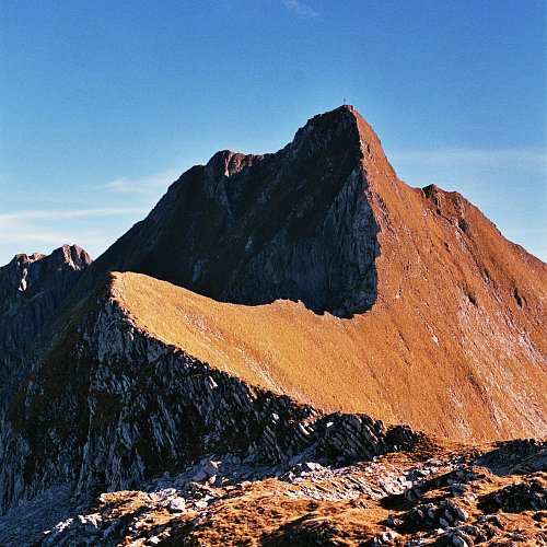

About peak Vanil Noir
 Švýcarsko
Vrchol Vanil Noir was added here by Martin Matějka and info was completed by Milan "Hojší" Průžek.
A very steep peak, accessible via steep marked paths, with the most difficult section secured by chains.
Elevation gain: 1050 m
Time to summit: 3 hours
Risk: the path on the steep limestone slope is very slippery when wet.
Ascent:
We leave the highway between Bern and Vevey at the Bulle exit and drive through one of the most picturesque Swiss villages, Gruyere, heading south to the neighboring village of Grandvillard. We navigate chaotically in Grandvillard, trying to make our way up into the mountains. If we find the sign for "Chute d'eau et cave", we stop to see a fairly decent waterfall. Then we continue wandering until we find the sign for Bounavaux. We head towards Bounavaux, parking at the end of the road. We walk to the Bounavaux hut. Above us towers Vanil Noir. We continue up the path for a while, and then the trail splits. The easier route to the summit is reportedly the one that goes right. We climb for about another hour on the hiking trail until we reach a saddle at an altitude of about 2250 m. The summit is not far, but we must take a narrower, "non-tourist" path, equipped with chains in the steepest sections. The nice thing is that you can descend the other side and make a nice loop (see map).
I climbed Vanil on a cloudy day in the summer of 2005. I dragged my complaining family up to about 2000 m, after which they refused to continue, saying that this was not a vacation. It is true that to hike up for three hours in fog and light rain just to hike back down again, one must be properly motivated. Fortunately, I am, and so I could add more to my collection of photos "Peaks in Fog and Rain". I assume there is a beautiful view from there; I only had the chance to feel the summit's metal cross, erected in memory of someone who was struck by lightning there, as thunder approached. Like other mountains in the area known as the "Prealps", Vanil Noir is predominantly limestone, thus quite slippery – Saint Peter was courteous enough to open the floodgates fully only after I returned to the hiking trail. On the way down, I picked up my lazy family at the hut, and in the downpour on the way to the car, we discussed whether it is necessary to regularly get soaked and frozen, or if it is better to forgo such pleasures. We also decided to get a stove for each corner of the living room because one should not skimp on stoves. My wife suggested that we could also set fire to the National Theatre, which I refused because we, the Brno folks, would have to pay for it again, just like back then when they forgot to put the lid on the metro. In conclusion, I think it is wonderful from a psychological perspective if one occasionally changes their value system and realizes that much more important than a pile of money and a cheerful trio of eighteen-year-olds is having a hot bath in a tub.
Parking lot - hut: 1 h (beginner)
Hut – ridge: 1.5 h (beginner)
Ridge - summit: 15 min (hiker)
See map
- Chalet/accommodation
-
There is no chalet on the peak.
- Stroller access
-
Peak is not stroller accessible.
- Views
-
There are views from the peak.
- Cable car
-
There is no cable car to this peak.
- Equipment
-
No special equipment is required for this summit.
- Accessibility
-
Peak is freely accessible.
Routes nearby
Routes provided by SvetOutdooru.cz
Sun
| today | tomorrow | day after tomorrow | |
|---|---|---|---|
| Dawn: | 7:29 | 7:30 | 6:32 |
| Sunrise: | 8:00 | 8:01 | 7:02 |
| Sunset: | 18:31 | 18:29 | 17:27 |
| Dusk: | 19:02 | 19:00 | 17:58 |