
Hiking, 57 km
16.5.2026
 Česko
Bruntál (Moravskoslezský kraj)
Logged on Vrcholovka 13x in total. Spočinek Hrad Rešov J was added here by Bohumír Michal and info was completed by Bohumír Michal.
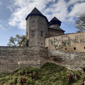
Hrad Rešov stood on rocky cliffs of the promontory above the confluence of the Huntava and Tvrdkovský streams. The most convenient access is from the church in Tvrdkov along the red trail. After about 2.5 kilometers, the path turns left towards the hill. After approximately 150 meters of walking on this path, it turns right towards the promontory, at the end of which the ruins of the castle are located.
In front of the castle, access from the north is interrupted by a ditch, partly carved into the rock, which is up to 12 m wide and reaches a depth of up to 4 m. On the rocky block, a forecourt is formed with a rear castle. Between the forecourt and the rear castle, there is a shallow ditch and behind it a rock face up to 4 m high, where the main tower-like structure of the castle's core can be assumed. The rear castle was probably surrounded by a stone wall, as indicated by the remnants of masonry on the western side.
The castle likely originated in the second half of the 13th century. It was situated at the boundary of the landowner's, bishop's, and private property. Given its presumed guarding and protective function, it was most likely built at the behest of the landowner. In the 14th century, the entire surrounding area belonged to Rabštejn, and by that time, the Rešov castle was already abandoned. Therefore, the castle is often referred to as the Abandoned or the Forgotten Castle.
There is no chalet on the peak.
Peak is not stroller accessible.
There are no views from the peak.
There is no cable car to this peak.
No special equipment is required for this summit.
Peak is freely accessible.
Nearest peaks: Hrad Rešov (540 m, 0.1 km) Soví skála SV (562 m, 0.2 km) Soví skála V (558 m, 0.3 km) Above Rešov Waterfalls (564 m, 0.6 km) Tvrdkovský lán (656 m, 0.9 km) U Bílého kamene (623 m, 1.2 km) Skaliska (638 m, 1.4 km) Jasný vrch (693 m, 1.7 km) Na Sedlákově (566 m, 1.7 km) Zadní hřbet (639 m, 1.8 km) Kamenolom (652 m, 1.9 km) Above the Bird Rock (544 m, 2 km) Lesný S (571 m, 2 km) Čtverka (584 m, 2.1 km) Ptačí vrch (490 m, 2.3 km) Lesný (540 m, 2.7 km) Ruda (551 m, 2.7 km) Skalka (685 m, 3.1 km) Lesný J (520 m, 3.3 km) Křížový vrch (589 m, 3.4 km) Špičák (778 m, 3.4 km) Front Owl (574 m, 3.5 km)
 Okruh po Litovelském Pomoraví
| today | tomorrow | day after tomorrow | |
|---|---|---|---|
| Dawn: | 6:02 | 6:03 | 6:05 |
| Sunrise: | 6:35 | 6:37 | 6:38 |
| Sunset: | 16:34 | 16:32 | 16:30 |
| Dusk: | 17:07 | 17:05 | 17:04 |