



Hiking
so, 23.4.2022, 15:00
 Česko
Most (Ústecký kraj)
Logged on Vrcholovka 1x in total. Vrchol Kapucín SV was added here by Tor and info was completed by Martin Matějka a Tor.
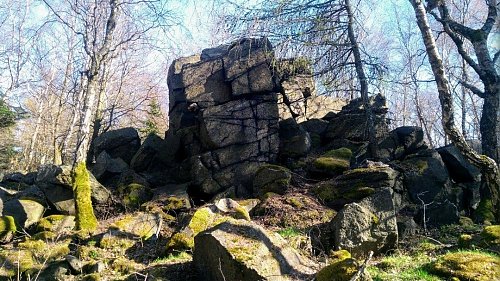
In the middle of the northeastern spur of Kapucín, extending to Točník, there is a terraced plateau. From it rises a heavily weathered and cracked frost cliff, which reaches a height of six meters and is accessible from the southeast by easy climbing. (Difficulty I. UIAA). Unfortunately, the view from it is obstructed by the surrounding tall forest.
There is no chalet on the peak.
Peak is not stroller accessible.
There are no views from the peak.
There is no cable car to this peak.
No special equipment is required for this summit.
Peak is freely accessible.
Nearest peaks: Kapucín (743 m, 0.4 km) Slaměník (660 m, 1.4 km) Černický vrch (575 m, 1.5 km) Čihadlo (792 m, 1.6 km) Josefinina skála (589 m, 1.7 km) Kopřivník (699 m, 1.8 km) Alberk (384 m, 2 km) Strážný vrch (767 m, 2.3 km) Bratrská JV (760 m, 2.9 km) Bratrská (777 m, 3.1 km) Hřeben (687 m, 3.5 km) Jánský vrch (751 m, 3.7 km)
| today | tomorrow | day after tomorrow | |
|---|---|---|---|
| Dawn: | 6:14 | 6:16 | 6:18 |
| Sunrise: | 6:48 | 6:50 | 6:52 |
| Sunset: | 16:50 | 16:49 | 16:47 |
| Dusk: | 17:24 | 17:23 | 17:21 |